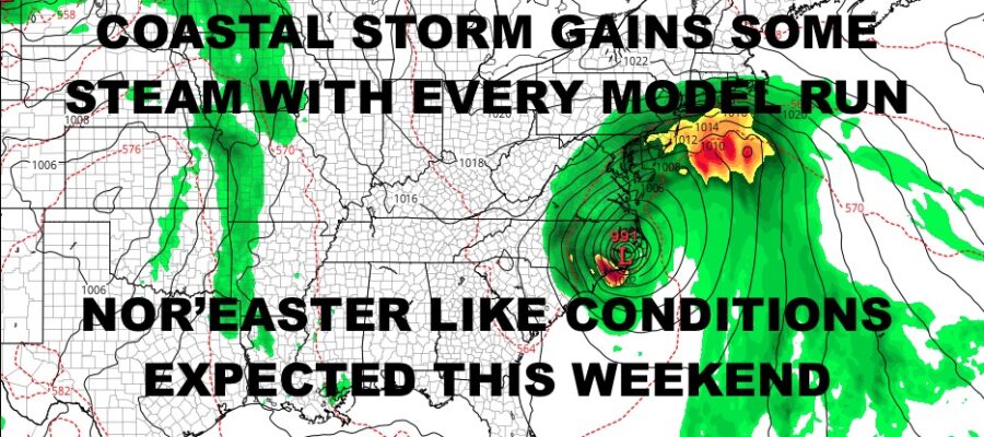
NYC Nor’Easter Like Conditions Expected This Weekend
Good morning everyone. We are enjoying our last few of days of summer with beautiful, mild, and dry conditions with sunny skies. However, things are about to change and our first day of fall is about as fall as you can get. We’re talking deep fall, November fall, as a coastal system that’ll form off of the Southeast coast, gets its act together and moves up the Eastern Seaboard.
Regardless of whether this is sub-tropical, post-tropical, or just a wave of low pressure, it doesn’t matter. The category-naming at this point is just semantics as regardless of what it is, it’ll bring Nor’easter-like conditions into the Northeast; especially New York City and Long Island.
Check out the local forecast below, plus we go into timing and what to expect on Saturday/Sunday.
SATELLITE

For today, we’ll enjoy mostly sunny skies with just a few high clouds around. Highs will be a pleasant mid 70’s.
Sunshine continues tomorrow, but high pressure on the move could keep things a bit cooler as our wind profile changes. Highs in the low to mid 70’s.
WEATHER RADAR

On Friday, high pressure that’ll force everything up the coast will be locked in place. We’ll start off sunny with increasing clouds late. Developing light but steady easterlies will help keep is in the upper 60’s to low 70’s. The upper 60’s will likely be along the immediate coast.
We have a chance of some rain overnight Friday, but the bulk of the rain is expected Saturday. Expect rain, heavy at times, with windy/gusty conditions. Strongest winds will be felt along the immediate shore for a very Nor’easter-like feel. We won’t go into wind strength yet, but I think 20-30mph with some higher gusts is a good bet at minimum. We could also see some coastal flooding during high tide cycles as we do with any given Nor’Easter. Highs in the mid 60’s at best.
Clouds stick around Sunday as the old low hangs back and the bulk of the energy heads off the coast. This will keep clouds and scattered showers around. Highs will be in the mid to upper 60’s.

Things will slowly improve on Monday with sunshine returning and highs 70-75. We’ll keep that mojo going on Tuesday, with sun & clouds and highs in the low 70’s. A little extra sunshine could give us a few mid 70 readings.
BE SURE TO DOWNLOAD THE FREE METEOROLOGIST JOE CIOFFI WEATHER APP &
ANGRY BEN’S FREE WEATHER APP “THE ANGRY WEATHERMAN!
MANY THANKS TO TROPICAL TIDBITS & F5 WEATHER FOR THE USE OF MAPS
Please note that with regards to any severe weather, tropical storms, or hurricanes, should a storm be threatening, please consult your local National Weather Service office or your local government officials about what action you should be taking to protect life and property.