
Weather in 5/Joe & Joe Weather Show Latest Podcast
NYC Nova Scotia Low May Open Door For An Interesting System
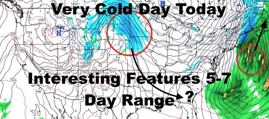
Good morning everyone. We have the core of very cold air over us today, and we are watching some features on the map for an interesting late week into early next week. Check out the latest below.
SATELLITE

We’ll have sunshine, a stiff NNW flow today, and highs in the upper teens to low 20’s. Lows overnight drop back into the mid teens, then we modify tomorrow fairly well. Look for a seasonably cold day tomorrow, sunshine, and highs in the mid 30’s.
WEATHER RADAR

Thursday is looking even better for this time of year, with sunshine continuing and highs near 40. Then things begin to take a turn on Friday. Low pressure will form off of the Southeast coast and head far enough offshore to keep the precip (or most of the precip) away from NYC & Long Island. The low will deepen into probably one of the strongest systems we’ve see in quite some time, and I wouldn’t be surprised to see storm/hurricane force wind warnings well offshore near George’s Bank and areas ENE.
Clouds will increase Friday as that system passes to our east, and it’ll become breezy/windy with highs in the low to mid 30’s.

As the low moves away and high pressure moves in, the tight pressure gradient will pull the very cold air back down from Canada and back into the area. Expect breezy/windy conditions Saturday, sunshine, and highs only in the near 20/low 20 range.
It’ll also open the door for another system to take a deep dive from the Dakota’s and down near the Gulf. It’ll pick up a lot of moisture, and we’ll be watching to see where it goes. If it happens to come up the coast, it’ll slam into that arctic air and dump A LOT of snow for someone. However, it’s too early to tell how this story is going to end, and we don’t do the “storm behind the storm” forecasts.
Let’s wait and see how Nova Scotia/extreme NE New England fares, then we can see what type of steering currents are behind it.
BE SURE TO DOWNLOAD THE FREE METEOROLOGIST JOE CIOFFI WEATHER APP &
ANGRY BEN’S FREE WEATHER APP “THE ANGRY WEATHERMAN!

MANY THANKS TO TROPICAL TIDBITS & F5 WEATHER FOR THE USE OF MAPS
Please note that with regards to any severe weather, tropical storms, or hurricanes, should a storm be threatening, please consult your local National Weather Service office or your local government officials about what action you should be taking to protect life and property.