
Weather in 5/Joe & Joe Weather Show Latest Podcast
NYC Eyes Shift Towards Sunday Monday With Many Unanswered Questions
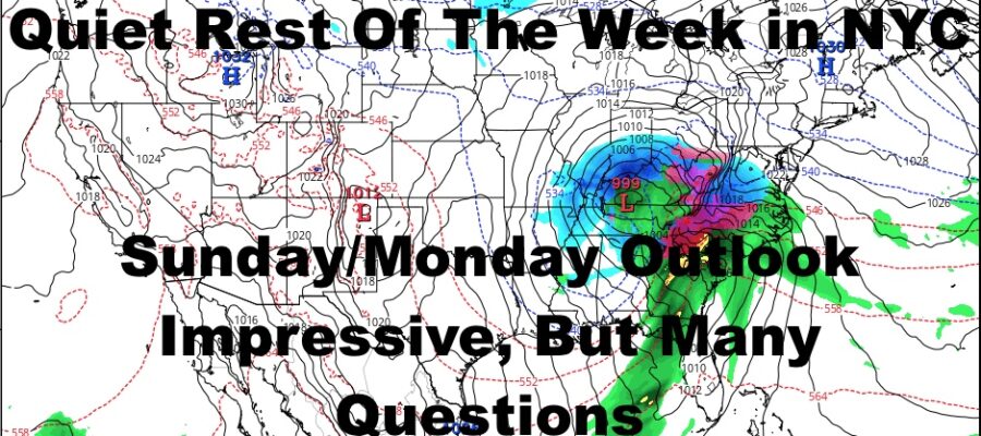
Good morning everyone. I’ll start out by addressing the 800lb Gorilla in the room – Yes, our late weekend/early week system looks like an inland-runner or near-coastal system. However, it doesn’t negate the impact our system will have along the East Coast/inland sections, and we are looking at a very impressive system regardless of path.
SATELLITE

For today, temps modify fairly nicely, with sunshine and near 40 temps for highs. We’ll keep the momentum going with mid 40’s tomorrow and a mix of sun and clouds.
While most outlets are not calling for it, I think we have increasing clouds on Friday as that big offshore low passes well to our east. As you go more east, the more clouds we’ll have, and the slight chance of a sprinkle on the Forks. Winds will increase and a sharp northerly flow will help pull down more very cold air. After mid 30’s Friday, we’ll have lows in the single digits to low teens.
WEATHER RADAR

Saturday is looking quiet but very cold. Expect a stiff breeze with highs in the near 20/low 20 range, and more single digits to low teens overnight. Clouds increase on Sunday ahead of that much-talked-about system coming.

It’s simply too early to tell what we’re looking at here as far as timing and precip types, but we are starting to see hints that this will be more of a complete inland route; or near-coastal route if steering currents allow a shift further east. A complete inland route would give us the chance of a brief period of wet snow or mix, changing to very heavy rain. A more near-coastal route could give us a prolonged period of heavy wet snow or mix, changing to heavy rain. Either way, somebody will be getting 1-2ft of snow where it stays all snow or mostly snow. Places such as upstate South Carolina and Western North Carolina, could put up some very impressive numbers if things work out.
BE SURE TO DOWNLOAD THE FREE METEOROLOGIST JOE CIOFFI WEATHER APP &
ANGRY BEN’S FREE WEATHER APP “THE ANGRY WEATHERMAN!

MANY THANKS TO TROPICAL TIDBITS & F5 WEATHER FOR THE USE OF MAPS
Please note that with regards to any severe weather, tropical storms, or hurricanes, should a storm be threatening, please consult your local National Weather Service office or your local government officials about what action you should be taking to protect life and property.