
COUPON CODE SUMMER24 GET 10% OFF
(Tempest is an affillate of Meteorologist Joe Cioffi & earns commissions on sales.)
NYC Pleasantly Warm Workweek Continues
08/13/24 12:22pm ET
Good afternoon everyone. We continue to have beautiful conditions in the Northeast courtesy of strong high pressure keeping a stationary front well to our south. That front will eventually make it back as a warm front, then a sweeping cold front will help protect the Northeast and East Coast as a whole from what-will-be Hurricane Ernesto.
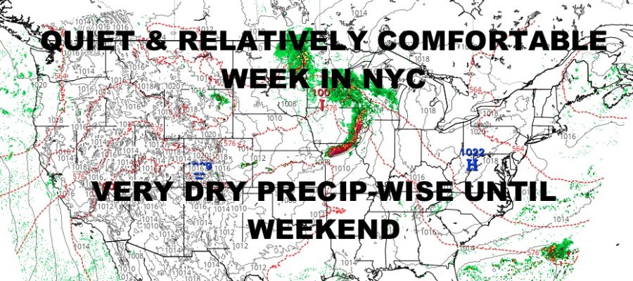
Ernesto is expected to make a run near or at Bermuda, which will equate to high surf and rip currents for several days along Mid-Atlantic and Northeast beaches. Overall though, we are quiet and relatively comfortable compared to what mid-August could be.
Currently and as expected, we have heavy showers and storms in eastern Kansas, Missouri, and northern Arkansas leftover from last night’s storms that gave localized areas some severe weather. We’ll watch this complex of heavy weather continue to move east/southeast, then begin to weaken somewhat.
The main focus will be the prospect of severe weather tomorrow night into Thursday morning as a vigorous disturbance comes out of the Upper Midwest and bangs into that hot, humid air. Look for scattered severe weather to develop in North and South Dakota, then begin to organize into a line as it reaches Minnesota, Nebraska, Iowa, and Wisconsin.
We’ll have to see when and where this line fully organizes, but we could see a Derecho type line of severe thunderstorms form in parts of Wisconsin, Iowa, Missouri, then into Illinois. Regardless of whether we reach Derecho parameters or not, we are expecting damaging winds in excess of 70mph, very large hail, torrential rain, and the prospect of strong tornadoes in a line that could extend hundreds of miles. The timeline as of now looks to be tomorrow afternoon into Thursday morning from northeast to southeast.
Here is your local NYC Metro forecast –
SATELLITE

We’ll have sunshine today, low humidity, and low 80’s for the perfect mid August day. The mojo continues tomorrow albeit slightly warmer, with mid 80’s likely.
WEATHER RADAR

Mid 80’s continue Thursday and Friday as humidity begins to creep up. We’ll remain mostly sunny and dry rain-wise though.

Humidity peaks on Saturday and Sunday with low to mid 80’s and the chance of PM storms each day. We expect this front to protect the East Coast from Hurricane Ernesto aside from heavy surf and rip currents along NYC, NJ, and Long Island beaches.
BE SURE TO DOWNLOAD THE FREE METEOROLOGIST JOE CIOFFI WEATHER APP &
ANGRY BEN’S FREE WEATHER APP “THE ANGRY WEATHERMAN!
MANY THANKS TO TROPICAL TIDBITS FOR THE USE OF MAPS
Please note that with regards to any severe weather, tropical storms, or hurricanes, should a storm be threatening, please consult your local National Weather Service office or your local government officials about what action you should be taking to protect life and property.