OMNITRUEVALUE.COM

WEATHER IN 5/JOE & JOE WEATHER SHOW PODCASTS
NYC Quiet 5-7 Day Stretch With Temps Modifying Monday
Good morning everyone. Our Nor’Easter is now gone, with very cold air for this time of season replacing it. Thankfully, it’ll only last a few days and we’ll be back in the 40’s by Monday. Enjoy the quiet stretch, because we go active again Thursday/Friday onward.
SATELLITE

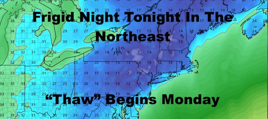
Expect morning clouds today with PM sun, a steady northerly flow, and highs in the upper 20’s to low 30’s; well below average for this time of year. The big story will be the cold tonight, where NYC will dip into the upper teens to near 20. Elsewhere, teens will be widespread, with some dingle digits upstate as radiational cooling takes hold. (Light winds, snow pack, and clear skies allow heat to escape faster)
REGIONAL RADAR

Tomorrow we remain cold but we also remain sunny. We’ll have more highs in the upper 20’s to low 30’s, but at least our low temps modify. Teens will be replaced upper 20’s to near 30, and those single digits upstate will be replaced with upper teens to low 20’s.
Sunday we “warm” up a bit, with upper 30’s to near 40 under sunny skies.
LOCAL RADAR NEW YORK CITY

Quiet and sunny is the theme here, but we’ll probably start to get some melting done Monday through Wednesday. Expect sunny skies throughout this period, with upper 30’s to low 40’s as highs.
Thursday will be our first chance of rain, and we’ll be in the “warm” sector of this next system. It’ll be in the form of a strong cold front, and ahead of it we’ll have 50-55 degree temps. We’ll have plenty of cold air behind it, and you may even see a brief changeover to a mix or wet snow if there’s enough moisture left behind that front, or a wave forms along it as it’s departing.
LOCAL RADAR PHILADELPHIA


In the long range, that Thur/Fri system will mark the beginning of another active period, with several chances of some coastal or near-coastal systems. As with yesterday’s forecast, we won’t get ahead of ourselves and take it one system at a time.
MANY THANKS TO TROPICAL TIDBITS FOR THE USE OF MAPS
Please note that with regards to any tropical storms or hurricanes, should a storm be threatening, please consult your local National Weather Service office or your local government officials about what action you should be taking to protect life and property.