NYC Quiet Week Ahead With Some Changes In Motion
Good morning everyone. We have a relatively pleasant work week ahead minus any rain of significance, nor any hot weather to speak of. However, the heat will be increasing again this weekend, but the gears of fall are turning in regards to the increasing speed of our systems, and any heat won’t last very long.
SATELLITE

This morning we are enjoying clear skies and a fresh breeze. Some upper air energy and “cool” air aloft may help touch off a few isolated popcorn showers and storms; so we’ll keep a slight chance in the forecast, but most of the action will be inland. Anyone who does see an isolated storm, could see some pea-size hail. Highs today will be a seasonal mid 80’s.
REGIONAL RADAR

Tomorrow and Thursday, we cool off a bit under mostly sunny skies and low humidity. This 2 day block will be the best weather of the week, with comfortable conditions and highs in the low 80’s. We may see a few mid 80’s tomorrow, but it all hangs on the wind profile.
Friday is looking a touch warmer with humidity increasing slightly, but we remain free of rain and highs will be in the mid 80’s.
LOCAL RADAR NEW YORK CITY

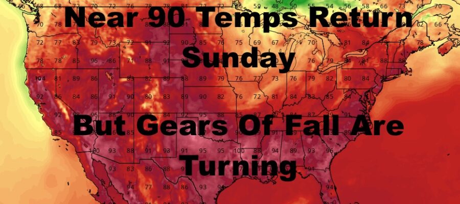
Very warm to hot weather begins to make a brief return for your weekend, with mid to upper 80’s and even more humidity Saturday. We still remain precipitation free, but at some point an approaching cold front could spark some storms Sunday and/or Monday depending on the timing. Highs Sunday will be a humid upper 80’s to low 90’s ahead of that front.
If the front hangs back for one more day, we could squeeze out another hot one on Monday, but we’ll wait on that. Behind that front, cooler and less humid air arrives for another 3-5 day block.
LOCAL RADAR PHILADELPHIA


All in all, we still have plenty of 80’s left in the season, as well as a few chances of near 90 or 90+ temps (Especially ahead of any approaching front). As you can see though, the fronts are starting to move a little faster, and the more comfortable days temp-wise are beginning to outpace the hot ones. This means the gears are fall are already starting to turn. We’ll also be watching for any prospects of severe weather, because this is the region’s prime time when these fronts move faster and are “sharper” in terms of airmass differences.
MANY THANKS TO TROPICAL TIDBITS FOR THE USE OF MAPS
Please note that with regards to any tropical storms or hurricanes, should a storm be threatening, please consult your local National Weather Service office or your local government officials about what action you should be taking to protect life and property.