NYC Rain Arrives Overnight
02/22/24 10:00am ET
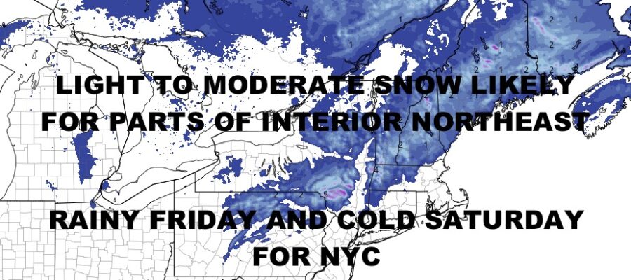
Good morning everyone. We have a quiet and “milder” day in the Northeast before some rain arrives along the coastal plain, and some interior light to moderate snows. On and off rain is expected in the big cities of the Mid-Atlantic, Northeast, and New England, but we’re not expecting anything life-altering here, just a rainy day tomorrow.
Rain moves in overnight tonight and into tomorrow will about mid to late afternoon from west to east/northeast. Light to moderate snow is likely in the higher elevations of interior parts of the Northeast and New England, but could stretch close to the coast up by Maine. As far as snow totals, this is generally a 1-3/2-4″ type system, but some of the highest peaks could see 4-6″. Again, not a big deal overall and typical for this time of season.
We continue to watch a bigger and more important system that’ll come ashore in the Pacific Northwest around Sunday, dive into the Rockies, and then re-emerge/reorganize in the Central Plains. This will increase that chance for tornadic storms and some severe weather as a whole with major temperature contrasts ahead and behind our cold front. As of now, it looks as if the threat develops between overnight Tuesday and Wednesday afternoon.
We’ll keep a close eye on this one as it is a very spring-like system and we all know spring is peak season for severe thunderstorms across the Plains and Southeast. Stay tuned and here is your local NYC Metro forecast –
SATELLITE

Expect AM sun today, then increasing clouds as the day goes on. We’ll be milder in the low to mid 40’s. Rain heads in overnight and should last until early afternoon tomorrow. Highs in the near 50 range will happen early, then temps should begin to drop before sunset as a breeze kicks in. It’ll be a cold one overnight tomorrow, with lows 25-30.
WEATHER RADAR

Saturday continues to look breezy and cold with mid 30’s, then very cold overnight as we dip into the upper teens to low 20’s. Sunday modifies fast, with more sunshine and low to mid 40’s.

We’re back up to near 50 on Monday as that elongated system out near the Rockies stretches well north of us and puts us in the mild quadrant once it finally does get here. As far as snow, there’s nothing in the immediate or moderate range in terms of snowstorms.
BE SURE TO DOWNLOAD THE FREE METEOROLOGIST JOE CIOFFI WEATHER APP &
ANGRY BEN’S FREE WEATHER APP “THE ANGRY WEATHERMAN!
MANY THANKS TO TROPICAL TIDBITS & F5 WEATHER FOR THE USE OF MAPS
Please note that with regards to any severe weather, tropical storms, or hurricanes, should a storm be threatening, please consult your local National Weather Service office or your local government officials about what action you should be taking to protect life and property.