NYC Rainy Raw Saturday Partial Clearing Tomorrow
Good afternoon everyone. As promised we have some rain and rawness to deal with all day today. Temps are on the decline and low pressure will help drop us into the upper 40’s by this evening. Even as I type, we have dropped form the mid 50’s to near 50 already, so upper 40’s isn’t much of a stretch.
The good news is that low pressure develops too late, which will equate to a better Sunday than previously expected early in the week. We may even see some late sunshine and a big rebound in temps tomorrow. Otherwise the workweek looks fairly quiet, with the chance of a shower here or there, but temps on the seasonable/seasonably cool side; nothing extreme.
We also continue to watch signs for a more significant system that could shape our last week of October. Models are showing that we could see a coastal/near coastal storm that’s on the strong side (if the ingredients come together), and that could be deep enough to pull down our first chilly air of the season, especially at night. If things unfold as shown, some areas could see their first freezes and frosts for the season.
SATELLITE

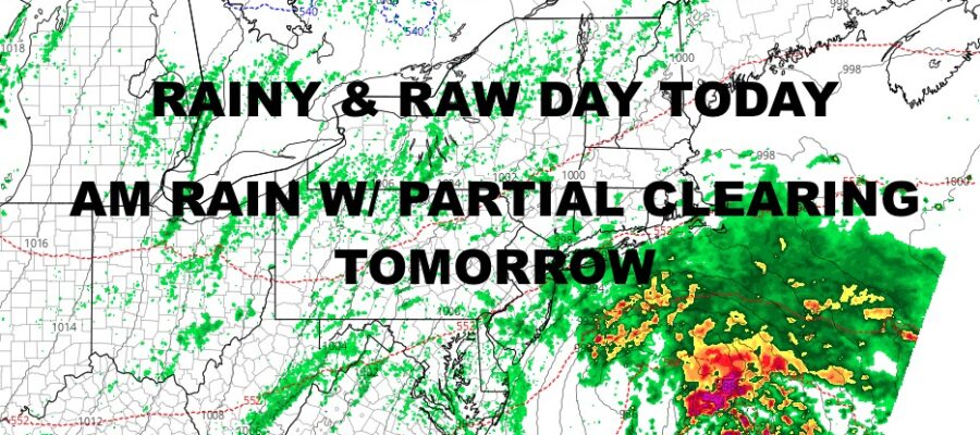
For today, there is no break. Expect steady rain for much of the day and temps sliding back into the 40’s. Look for steady temps overnight as those clouds act as a thermal blanket, so don’t expect any extreme lows even though it’ll be cool today.
Tomorrow, expect morning scattered showers, then partial clearing. we should see enough sun to get us to near 60, then mid to upper 40’s overnight.
WEATHER RADAR

Your workweek starts off sunny, then increasing clouds late on Monday. Highs near 60 again. We could see a scattered shower or two overnight Monday into Tuesday AM, then clearing again with highs near 60.
Sunshine and dry weather prevails Wednesday, with highs in the 60-65 range for a perfect day. Thursday and Friday could be milder depending on the front and positioning of high pressure. For now we will keep things conservative, with sunshine and highs in the mid to upper 60’s.

We will continue to watch the prospect of our next system some time after Friday, with a 2-3 day margin of error at this point. It’s simply too far out.
Stay tuned.
BE SURE TO DOWNLOAD THE FREE METEOROLOGIST JOE CIOFFI WEATHER APP &
ANGRY BEN’S FREE WEATHER APP “THE ANGRY WEATHERMAN!
MANY THANKS TO TROPICAL TIDBITS & F5 WEATHER FOR THE USE OF MAPS
Please note that with regards to any severe weather, tropical storms, or hurricanes, should a storm be threatening, please consult your local National Weather Service office or your local government officials about what action you should be taking to protect life and property.