
Weather in 5/Joe & Joe Weather Show Latest Podcast
NYC Showery New Year’s Eve & New Year’s Day Washout Expected
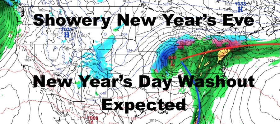
Good morning everyone. Our quiet period continues until Thursday, where our next big system is expected to begin to push through. This one doesn’t look as powerful wind-wise as the Christmas system due to the positioning of low pressure and the fronts getting stretched out, but I actually think this one has the potential to dump more rain.
SATELLITE

For today, sunny skies and chilly conditions dominate. Winds will be lighter today than yesterday, so things will feel more comfortable. Highs today 35-40.

Tomorrow we have that warmer airmass pushing through ahead of a weak system going well to our north. This will bring some clouds into the area, but I’m confident we see some blue patches. Highs tomorrow a milder 45-50.
Tuesday we cool off again and go chilly once more, but sunny skies continue. We’ll have a steady breeze with highs in the mid 30’s. Wednesday doesn’t look much warmer, but the winds settle down again for a more comfortable feel, Highs 35-40.

New Year’s Eve Day continues to look warmer and wet as part 1 of our elongated system drapes itself across the area. Look for clouds to lower and thicken as the day goes on, then showery conditions from late afternoon/early evening to go all night and into Friday. Highs Thursday 50-55, with temps holding near steady overnight, maybe dropping just a couple of degrees.
The heavier and steadier rain heads in on Friday as Thursday’s cold front pushes back through as a warm front, then the main cold front pushes through some time in the evening or nighttime hours. Overall, I think this system has the potential to drop 2-4″ of rain over the course of Thursday & Friday. This means that we might see some localized street flooding in poor drainage areas, as well as flooding potential upstate where there’s still some snowpack.
BE SURE TO DOWNLOAD THE FREE METEOROLOGIST JOE CIOFFI WEATHER APP &
ANGRY BEN’S FREE WEATHER APP “THE ANGRY WEATHERMAN!
MANY THANKS TO TROPICAL TIDBITS FOR THE USE OF MAPS
Please note that with regards to any severe weather, tropical storms, or hurricanes, should a storm be threatening, please consult your local National Weather Service office or your local government officials about what action you should be taking to protect life and property.