
Weather in 5/Joe & Joe Weather Show Latest Podcast
NYC Tropical Update Eyes Watching Tropical Storm Henri Closely
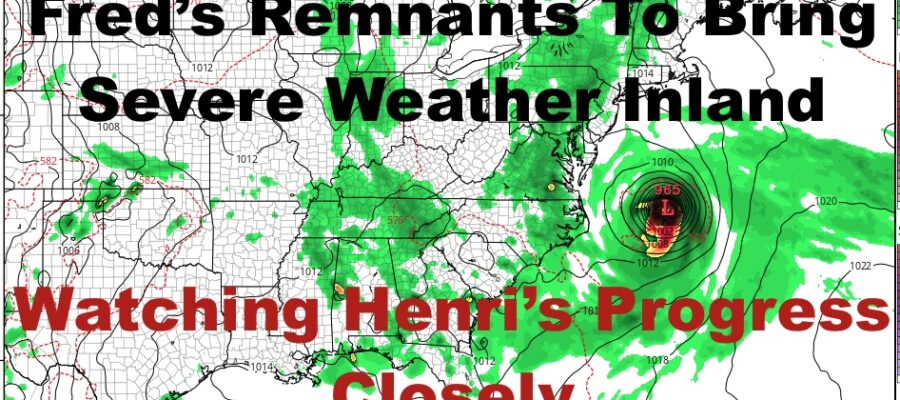
Good morning everyone. Clouds continue to be socked into the area, and we remain on that trajectory till late tomorrow/Friday in terms of seeing some blue patches. Fred’s remnants are beginning to make its run through the Northeast, and eyes turn to Henri as the forecast becomes more complicated.
SATELLITE

For today, expect cloudy skies, humid conditions, and the slight chance of a shower. Highs in the low 80’s. Come later this afternoon/evening, we’ll see Fred interact with the heating and instability, enhancing its energy and sparking off a line of very heavy rain & severe storms. The majority of the action will remain inland, but we still have to watch the tip of Fred’s “tail” as he goes west and north of us. If the line does reach down into the NYC/LI area, expect a brief round of very heavy rain, gusty winds, and the slight chance of a brief tornado. For us, the best chance of any precip is overnight/very early morning tomorrow.
WEATHER RADAR

Any AM showers tomorrow should cease and we’ll have very warm conditions with muggy conditions. We’ll also see some blue patches tomorrow afternoon and highs in the mid to upper 80’s. Mid to upper 80’s and muggy conditions continue on Friday, with the slight chance of a shower under a mix of sun & clouds.
Depending on the sunshine, we’ll see another mix of sun and clouds, the slight chance of a shower, and highs in the mid to upper 80’s.

For the moment, Sunday is looking complicated. Things could swing either way, but we’re watching the timing between maritime high pressure building in, and future Hurricane Henri. If high pressure beats out Henri, we could see a more westward trend. If Henri can slip by without being influenced by the high, he’ll go quietly out to sea with high surf, rough seas, and rip currents here.
Fringe effects are the best case scenario at this point. If things trend more westward, we could see a brushing or worse, direct impacts. This is going to be one that has fairly short notice, so now is the time to go through your supplies and plans in case things don’t work out in our favor.
BE SURE TO DOWNLOAD THE FREE METEOROLOGIST JOE CIOFFI WEATHER APP &
ANGRY BEN’S FREE WEATHER APP “THE ANGRY WEATHERMAN!

MANY THANKS TO TROPICAL TIDBITS & F5 WEATHER FOR THE USE OF MAPS
Please note that with regards to any severe weather, tropical storms, or hurricanes, should a storm be threatening, please consult your local National Weather Service office or your local government officials about what action you should be taking to protect life and property.