NYC Tropical Update Tropical Storm Isaias Takes More Northerly Route
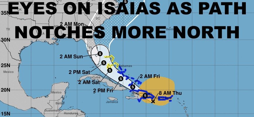
Good morning everyone. The gears are turning in the tropics, and we shift away attention for the heat today to focus on Tropical Storm Isaias. As things become more clear and Isaias finally became more organized, its become apparent that the track will be slightly more north as opposed to raking over the islands of Hispanola and Cuba. We’ll discuss everything below, but first the local forecast.
SATELLITE

Today we’ll have yet another hot one, with widespread 90-95+ degree temps. We’ll have the slight chance of PM storms, but the action will be rather scattered. Any storms that do form may contain frequent lightning, hail, gusty winds, and torrential rain.
Those storms are in response to a brief wind shift and airmass exchange that’ll occur tomorrow, before the very warm/hot temps fight back Saturday. Expect lots of clouds tomorrow, a steady NE breeze, the slight chance of some showers & storms, and highs in the mid 80’s. Regardless of the brief temperature drop, it won’t be very refreshing. Dewpoints will be high, making for a muggy day with a moisture-laden atmosphere.
REGIONAL RADAR

Your weekend is looking decent and very typical for the end of July/early August. Look for more sun than clouds on Saturday, dry conditions in terms of no storms, but humidity will begin to increase with highs in the upper 80’s to near 90.
Moisture will begin to increase up and down the east coast on Sunday, with a chance of scattered showers and storms pretty much anywhere at anytime. Don’t cancel your outdoor plans though and just keep an eye to the sky. Highs will be a muggy upper 80’s to near 90.
LOCAL RADAR NEW YORK CITY

To start next week, we’ll be keeping a close eye on Isaias. Right now nothing is written in stone and Isaias may go out to sea with a whimper. However, my main concern right now is the more northerly track. As of now, the National Weather Service has it as a tropical storm its entire path. Depending on whether the atmosphere is friendly for development or not shear-wise, this may be true, but I’d keep a close eye for some rapid changes if they occur.
Less interaction with land increases the chance for fast development if Isaias’ circulation becomes better organized. It’s not something that’ll happen now (if it happens at all) due to interaction with the mountainous Caribbean islands, but I’d start paying attention once it nears the most eastern Bahamas.
Again, it’s too early to predict the final path, and my biggest concern is the possibility for rapid and unexpected development a few days down the road.
Stay tuned and we’ll update on a daily basis.
LOCAL RADAR PHILADELPHIA


MANY THANKS TO TROPICAL TIDBITS FOR THE USE OF MAPS
Please note that with regards to any tropical storms or hurricanes, should a storm be threatening, please consult your local National Weather Service office or your local government officials about what action you should be taking to protect life and property.