NYC Very Warm To Hot Week Brewing
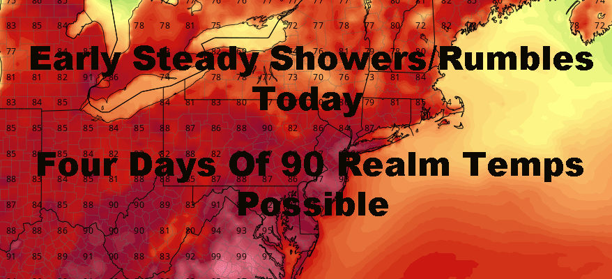
Good morning everyone. We have a band of moderate to heavy rain crossing the area as we speak, which may contain a few rumbles of thunder. This represents warmer and much humid air that’ll stick with us for several days, but it’ll happen in baby steps, which I’ll explain below.
SATELLITE

For today, expect a morning round of showers and storms; then a chance of a scattered shower or storm at any time until late afternoon. This represents a much warmer dome of air heading into the entire region, but we’ll hold off on the big numbers today. Look for highs ranging from low 80’s to possibly some mid/upper 80 hits IF we get some sun in the area. It’ll be very humid as well today.
REGIONAL RADAR

Tomorrow, a light NW flow dries us out, but we’re under a dome of very warm air, so expect things to heat up fast. Expect upper 80’s to low 90’s tomorrow, and that’ll translate all the way to the coast with that NW wind. Our temps will feel different tomorrow compared to what’s down the road, because it’ll be a dry heat.
LOCAL RADAR NEW YORK CITY

On Thursday, we increase the humidity a notch as winds go more WSW instead of NW. Sunny skies remain and we look to go for upper 80’s to low 90’s once again. Slightly cooler along the shore.
Friday is the big one and we discussed this yesterday. We’re looking at your all-out, staple, July day on Friday; with sunny skies, very warm/hot and humid. Upper 80’s to low 90’s will be on the menu again, but with the humid conditions, it’ll feel more oppressive. Cooler along the shore.
LOCAL RADAR PHILADELPHIA


The jury remains out on the weekend, but it looks as if we may squeeze out one more hot and humid one for Saturday, before a “cooler” airmass tries to kick the heat out for a little while.
For the moment, I’m going to go with another typical summer day on Saturday, adding that chance of afternoon showers and storms; more upper 80’s to low 90’s. IF we can kick everything out cleanly, then we could have a sunny and breezy Sunday, with highs in the low to mid 80’s – still warm but more dry.
My July 4th Hail-Mary holds as well in terms of a decent day, but it could wind up being more dry as well.
MANY THANKS TO TROPICAL TIDBITS FOR THE USE OF MAPS
Please note that with regards to any tropical storms or hurricanes, should a storm be threatening, please consult your local National Weather Service office or your local government officials about what action you should be taking to protect life and property.