
Weather in 5/Joe & Joe Weather Show Latest Podcast
NYC Vigorous Storm Takes Shape Late Sunday Arrival
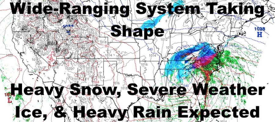
Good morning everyone. Our much anticipated system is beginning to take shape, and first in its sights will be the Southeast and Mid-Atlantic. This is going to be a doozy in terms of wide-ranging conditions, including severe thunderstorms, heavy ice accumulations, heavy snow, heavy rain, strong winds, and coastal flooding. We’ll go over it below as far as timing and what to expect.
SATELLITE

We start off quiet today but very cold. In most spots, temps may not get to 20 or barely break 20. Overnight, we drop back down into the single digits to low teens. Unfortunately for snow lovers, even cold air on this level won’t be able to lock into NYC with the path our low is taking.
Clouds will increase tomorrow as low pressure begins to head up the coast, but taking the inland route near the I95 corridor. Winds won’t be favorable for an all snow event, but we may see a brief period of light snow starting some time between 5-8pm, but quickly changing to mixed precip, then a windswept rain. Don’t get excited if you see some big flakes before the changeover, that’s just the warm air increasing in the atmosphere as ESE winds pull air in off of the relatively warmer ocean.
Winds will gust in the near 50mph range for NYC, but areas along the immediate south facing shores, the east end of LI, and especially Block Island, Nantucket, and Marthas Vineyard; could see some gusts in the 55-70mph range. Coastal flooding will also be an issue as that ESE fetch pushes water in during our full moon phase. Take action to protect property if you live in an area that floods during Nor’Easters.
WEATHER RADAR

Expect early AM heavy rain on Monday, with maybe even a rumble of thunder. Things will relax a bit as we enter the dry slot, then winds will whip around from the NW to pull down colder air. Temps will drop through the 40’s, and any remaining scattered showers may end as some light snowflakes.
Overall, I’m staying away from snow maps because the system is so dynamic, heavy snow will dot the upper elevation areas mere miles away from spots that’ll see heavy ice. The best chance of seeing all snow, will be western NY and the Finger Lakes area, where 10-15″+ is likely, and a few spots may see 18-24″ where heavy banding occurs. Higher elevations of the Poconos will see heavy snow, but they may get into some ice, as well as the valleys.

Tuesday looks sunny, breezy, and seasonably cold with highs in the mid 30’s. Winds relax on Wednesday, with more sunshine and near 40 temps.
BE SURE TO DOWNLOAD THE FREE METEOROLOGIST JOE CIOFFI WEATHER APP &
ANGRY BEN’S FREE WEATHER APP “THE ANGRY WEATHERMAN!

MANY THANKS TO TROPICAL TIDBITS & F5 WEATHER FOR THE USE OF MAPS
Please note that with regards to any severe weather, tropical storms, or hurricanes, should a storm be threatening, please consult your local National Weather Service office or your local government officials about what action you should be taking to protect life and property.