NYC Weekend Weather Depends On High Pressure Longevity
Good morning. We have another perfect, seasonably cool day here in the NYC area as our forecast is coming more into focus for mid/late week. We also see the signs of everything coming together with what we discussed yesterday, but there are some lingering questions as to how long high pressure can hold on.
SATELLITE

Today’s an easy one. Look for sunny skies, lighter winds and 70-75 degree temps in most spots. Clouds will begin to increase slowly overnight/tomorrow morning in response to our next approaching system.
With the failure of a ridge building in the Southeast, I think at this point we get everything done in 1 shot rain-wise, as opposed to 2 separate pieces of energy stretched 24-36hrs apart. Expect a slight chance of showers late morning/early afternoon tomorrow with the leading edge of warmer air; then we have a better shot at some heavier showers and thunderstorms tomorrow night, starting somewhere between 10pm – 2am. Locally, parts of the area could squeeze out an inch or so where the heavier rain sets up. This may cause localized flooding in the usual spots with poor drainage. Highs tomorrow 80-85 (sunshine dependent), and cooler at the immediate shore.
The chance of showers and storms will last through Thursday morning, then we begin decreasing clouds. Upstate, some leftover energy could help give you some scattered popcorn-type thunderstorms in the afternoon; and those could contain gusty winds and small hail. Highs Thursday will be a breezy upper 70’s to low 80’s (sunshine dependent).
REGIONAL RADAR

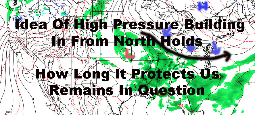
High pressure settles in nicely to protect our Friday and Saturday as tropical moisture drifts northward into the Midwest. This will help suppress everything temporarily and push everything into the Southeast as it tries to move eastward.
Look for sunny, pleasant, and seasonably average temps both Friday and Saturday with highs in the upper 70’s to low 80’s. Our average highs this time of year are about 77-79 depending on what source you use, so we’re right on the mark for the first 1/3rd of June.
Sunday we await to see if high pressure holds on long enough to give us a decent day. As of now, my spidey sense says that we hold onto most of the day, then await to see if any showers sneak in from next system; “charged up” by our tropical moisture.
Regardless of whether it happens Sunday, Monday, or Tuesday, I think once that high pressure lets go, we are in for a very rainy time. I’m talking a soaking, complete washout at some point.
LOCAL RADAR NEW YORK CITY

LOCAL RADAR PHILADELPHIA


MANY THANKS TO TROPICAL TIDBITS FOR THE USE OF MAPS
Please note that with regards to any tropical storms or hurricanes, should a storm be threatening, please consult your local National Weather Service office or your local government officials about what action you should be taking to protect life and property.