NYC Widely Scattered Storm Risk Precedes Very Warm Dry Sunday
Good morning everyone. We have some more typical August weather today and ahead of us in the NYC area for the next week or so. Meanwhile, our models continue to have a rough time in the long range, continuing kick the can down the road on unseasonably cool air that may never come or just visit very briefly.
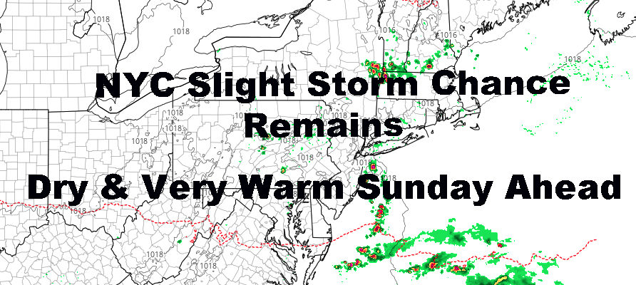
SATELLITE

For today, we’ll have a rather weak front sinking south towards the area. The front itself won’t pass through till some time between 11pm and 2am tonight, but with moisture still lagging around to our south, we could see some scattered storms drifting northward from the ocean into the area. Usually, anything that comes in from the ocean this time of year will be more of a tropical nature than anything else; so any storms that do form will be capable of frequent lightning and torrential rain. Highs today in the mid 80’s and humid.
Tomorrow, we dry out and make things a little toasty. As far as real-feel, it’ll probably feel the same as today, but on paper we will be hotter. Expect sunny skies, light northerlies, relatively low humidity, and highs in the upper 80’s to maybe a few low 90’s.
REGIONAL RADAR

To start the week, high pressure drifts away and gives us a more maritime fetch, but a light one at that. We’ll hold onto dry and sunny weather, but we sink back down into the low to mid 80’s.
Warmer and more humid air returns on Tuesday, and then we’ll introduce a more active pattern for the remainder of the week. We should have 1 more dry day on Tuesday with mid to upper 80’s, then we’ll have the chance of storms each day moving forward, with mid to upper 80’s and humid throughout.
LOCAL RADAR NEW YORK CITY

As of this very moment, next weekend is looking dry, with everything moisture-wise getting out of here by late Friday or overnight Friday. Temp-wise, Saturday is looking seasonably warm for now, but Sunday might be on the cool-side IF the cool push is strong enough, and departing low pressure well to our north is strong enough to help usher in that cooler air.
There’s a lot of variables here and even if it does happen, don’t expect fall to begin next weekend. 1-3 days of mid to upper 70’s would on the menu before more seasonal temps return; with even some more hot weather possible before we close out August.
LOCAL RADAR PHILADELPHIA


MANY THANKS TO TROPICAL TIDBITS FOR THE USE OF MAPS
Please note that with regards to any tropical storms or hurricanes, should a storm be threatening, please consult your local National Weather Service office or your local government officials about what action you should be taking to protect life and property.