OMNITRUEVALUE.COM

WEATHER IN 5/JOE & JOE WEATHER SHOW PODCASTS
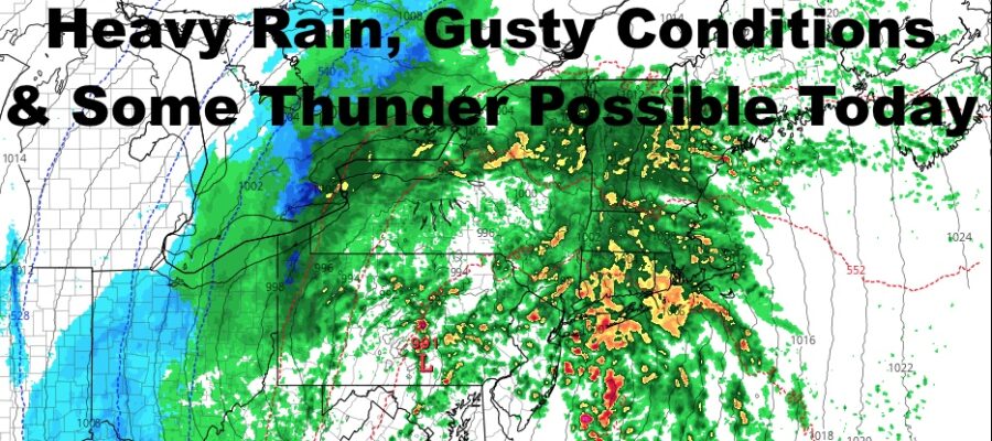
NYC Windswept Rain With Some Thunder Possible
Good morning everyone. Our fairly vigorous system is upon us, bringing with it some needed rain and unwanted wind. After everything passes, cooler air heads in, then we modify quickly towards the end of the week. Overall, the pattern is becoming more active, but this will probably be our strongest system until some time mid month.
SATELLITE

You can see our system getting together as brighter white cloud tops are starting to show off the coast of NC, VA, MD, and NJ. Thats all part of the plume of moisture/energy that’ll head north ahead of our approaching system.
Expect rain to start shortly, and it’ll be light throughout the early morning. Rain will increase in intensity, as well as the wind, and we should see heavy rain between 12-4pm, then a brief break. As the rest of the energy sweeps by, we could see some thin/brief lines of scattered heavy showers for our late afternoon/evening. Don’t be surprised to hear a few rumbles of thunder, as well as a brief marine warning or severe thunderstorm warning. If so, it’s all wind related.
We have wind advisories up for Long Island, and most of the strongest winds will be confined to the immediate south-facing shores & eastern Suffolk. Generally speaking, we’ll see 20-30mph sustained winds for the City, with gusts to near 40mph (Rockaway/JFK airport may see slightly higher gusts). Long Island will see 25-35mph sustained winds with gusts near 50. Again, the higher readings will be at the immediate shore. To our north & west, winds will be of no consequence and it’ll just be a breezy/rainy day.
REGIONAL RADAR

Aside from some scattered overnight and AM sprinkles, we begin to clear out and cool off tomorrow. Highs temps will be at midnight, and upper 40’s to low 50’s will drop into the low to mid 40’s before sunset tomorrow. Expect breezy conditions as well.
That chilly air sticks around for Wednesday, and we’ll have sunny skies, lighter winds, and highs in the low to mid 40’s.
LOCAL RADAR NEW YORK CITY

Average highs for this time of year are in the upper 40’s, and we’ll be near that mark for Thursday as things modify quickly. Expect more sunshine, upper 40’s to near 50, and a nice day overall.
Near-average weather continues for Friday, and we’ll see more temps around 50.
LOCAL RADAR PHILADELPHIA


In the long range, we have a lot of little systems crossing the area or just missing us off of the coast. These will help reinforce some cooler/colder air into the area, but I see nothing extreme going on. Our next chance for any moderate to significant precip, will probably be some time mid-month.
MANY THANKS TO TROPICAL TIDBITS FOR THE USE OF MAPS
Please note that with regards to any tropical storms or hurricanes, should a storm be threatening, please consult your local National Weather Service office or your local government officials about what action you should be taking to protect life and property.