DOWNLOAD MY NEW FREE JOESTRADAMUS WEATHER APP FOR ALL DEVICES
THE APP IS ABSOLUTELY FREE TO ALL BUT CONSIDERING SUBSCRIBING TO PATREON FOR A WEATHER EXPERIENCE FREE OF ADS, EXCLUSIVE VIDEOS FOR MEMBERS ONLY AND MUCH MORE…STARTS AT $2 A MONTH..MESSAGE ME AT ANY TIME
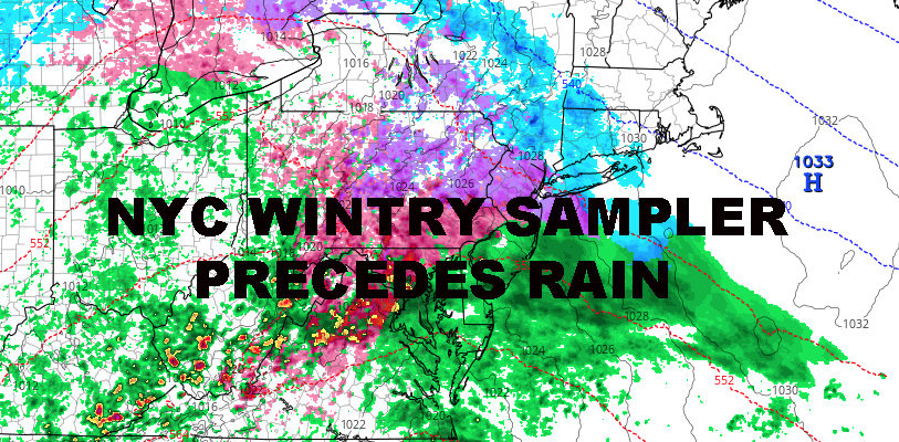
NYC WINTRY SAMPLER TOMORROW PRECEDES RAIN
Good morning everyone. More wintry precipitation is heading towards the NYC area, but once again it is a fleeting proposition and won’t last through the entire system. Meanwhile, our pattern goes from hostile to all-snow systems, to hostile towards any snow at all.
EASTERN SATELLITE

Look for sunny and seasonably cold, maybe even a touch below average today, with a steady light breeze and highs in the low to mid 30’s. Overnight, we dip into the low to mid 20’s, but we could have some teens in surrounding spots away from the NYC area.
REGIONAL RADAR

For tomorrow, the complicated forecast begins once again. A large, moisture-laden system, heads up from the west/southwest; and in familiar fashion, gives us some overrunning precipitation in a cold air environment, before giving way to a warmer atmosphere and rain.
Look for snow to begin between 2-5pm tomorrow and we could see a period of moderate to heavy snow before mixing occurs. Expect a coating to 2″ throughout most of the area before that transition begins, then we go to a plain cold rain before midnight tomorrow.
Anything that does fall will be long gone as temps rise tomorrow night, then into the upper 40’s to low 50’s Thursday with early morning rain and PM clearing.
LOCAL RADAR NEW YORK CITY

That brings us back to the familiar pattern we’ve had, except we’re starting to see temps rise a bit. Expect mid 40’s of Friday with sunny skies and breezy conditions.
Your weekend continues to look like a split, but Saturday looks to stay dry through most of it. We’ll have increasing clouds Saturday as the day goes on, highs in the mid 40’s. Then, rain moves in Saturday night and into all day Sunday and upper 40’s to low 50’s as highs; so don’t expect to see any flakes.
In the long range, there’s no snow in sight and temps remain seasonal to slightly above average. There are no 60’s and 70’s on the horizon, but there are also no 20’s as highs either. We still remain active and will watch each system for any surprises, but there’s nothing snow-wise in the immediate or intermediate range.
MANY THANKS TO TROPICAL TIDBITS FOR THE USE OF MAPS
Please note that with regards to any tropical storms or hurricanes, should a storm be threatening, please consult your local National Weather Service office or your local government officials about what action you should be taking to protect life and property.