
DOWNLOAD MY NEW FREE JOESTRADAMUS WEATHER APP FOR ALL DEVICES
THE APP IS ABSOLUTELY FREE TO ALL BUT CONSIDERING SUBSCRIBING TO PATREON FOR A WEATHER EXPERIENCE FREE OF ADS, EXCLUSIVE VIDEOS FOR MEMBERS ONLY AND MUCH MORE…STARTS AT $2 A MONTH..MESSAGE ME AT ANY TIME
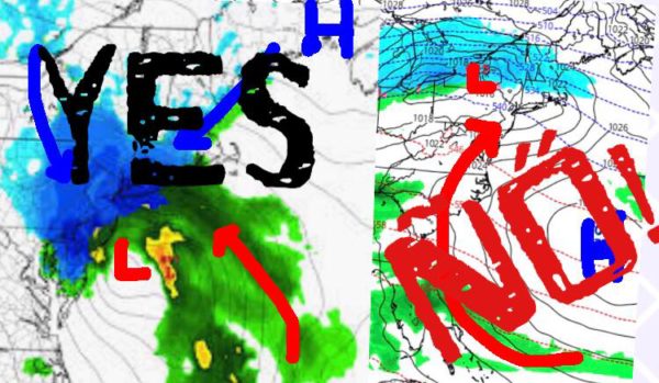
INTERNET GRABBING NYC SNOWSTORM STRAWS
Good morning everyone. After a brief taste of winter yesterday before things turned to rain, we’re back into thaw-mode here in the NYC area. Before anyone reads ahead and gets upset, we CAN STILL get a full-fledged snowstorm in New York City, but not with the current setup/pattern.
EASTERN SATELLITE

After some clouds to start, we have a pretty decent day for late February ahead of us. Expect partial clearing, light to steady westerlies, and highs in the upper 40’s to low 50’s. That should melt whatever we have left aside from anything stubborn in the shadows.
To end the week, we’ll have full sunshine tomorrow and slightly above average temps with highs in the mid 40’s.
REGIONAL RADAR

Your weekend continues to look like a split, which was has been expected now for several days. We’ll have increasing clouds on Saturday, but it’ll remain dry; highs in the upper 30’s to low 40’s. Rain moves in later Saturday night, with lows staying fairly steady.
For Sunday, we find ourselves in the warm zone of our system. There will be no mixed precipitation or snow changing to rain with this one as we go for near 60 temps and gusty south winds. Rain should clear on out by late morning/early afternoon and cooler air will begin to move in Sunday night to start the week off.
LOCAL RADAR NEW YORK CITY

Your start to next week looks seasonably cool and windy, with Monday’s highs in the low 40’s, then we dip into the upper 30’s for Tuesday. We’ll be keeping an eye on yet another system for Wednesday, but as of now things are very questionable as to how organized things get.
It could be another case of two pieces of energy slipping to the north and south of us fairly quickly; touching off a few rain or snow showers mixing with rain.
CRYING, WAITING, HOPING
In the long range, we’re back to hoping we squeeze out snowstorms during impossible setups. Just like the last two, you simply cannot get all snow in the NYC/Long Island area when low pressure arrives from the west and high pressure is not in the optimal spot.
It’s a matter of geography for our area. The two main scenarios that produce all snow in our area are –
A. A Nor’Easter-type system in which low pressure moves up the coast (not too close) or redevelops off off the coast (not too close) during a transfer of energy. Meanwhile, high pressure digs in to our north/northeast, keeping just enough cold air to keep things snow, but not too much dry air to suppress things too far to our south.
B. A clipper-like system swoops down from Canada with it’s own cold air, and brushes a large swath of 1-4″ snows across the area. Once in a while, they energize as they near the coast and things get enhanced, but they are typically quick-movers; hence the clipper name.
Anything we’ve seen this year storm-wise aside from November, cannot produce all snow. We have an ocean next to us and 1000+ miles of coastline to pump in enough relatively warm air from the south, the east, or the northeast to change things over in a heartbeat. Again, we can still see some snow. We can still see a snowstorm, but as time goes on, it’s going to get harder and harder and things are going to have to be even more “perfect” to pull it off late in the season.
Be weary of outlets grasping at straws and turning systems such as yesterday, into situations they simply cannot produce due to our geography and micro-climate. In the end, the clock is ticking on our season. That’s not personal feelings, that’s mathematics.
LOCAL RADAR PHILADELPHIA


MANY THANKS TO TROPICAL TIDBITS FOR THE USE OF MAPS
Please note that with regards to any tropical storms or hurricanes, should a storm be threatening, please consult your local National Weather Service office or your local government officials about what action you should be taking to protect life and property.