QUICK SHOT NYC POST EASTER SNOW EXPECTED
QUICK SHOT NYC POST EASTER SNOW EXPECTED
QUICK SHOT NYC POST EASTER SNOW EXPECTED – Good morning everyone. Yesterday I discussed how there are no big snowstorms coming to the NYC area regardless of the media hype. I also discussed how to get snow in the area during April and what it would look like for that to happen. Today, I will tell you how it’s going to happen and I’ll start by saying that it’s not going to be a big deal.
First, we start off with a sunny and mild day today, highs 55-60 with NW winds slowly switching around to the SSW. It’ll be slightly cooler at the shore with those colder than normal ocean waters. Tonight, we cloud up and we’ll have the slight chance of showers as a weak airmass transits the area. For Easter Sunday, we start off with clouds and maybe some early morning drizzle, then partial clearing and highs again 55-60; cooler at the immediate shore.
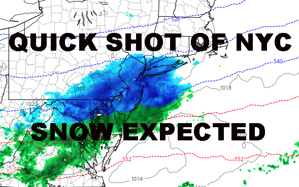
First and last call snow map
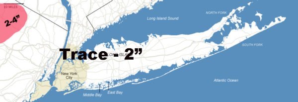
Tomorrow night, we cloud up once again as another weak disturbance slips to our south. This one will be a little more vigorous, timed with colder air coming in. Starting off as an overrunning band of precip and at night (two things we discussed for April flakes), we’ll see some light rain or mix turn to wet snow. It may take some time to stick, but we could eek out a trace to two inches on colder surfaces (cars, trees, grass, etc) depending on how fast it falls.
Any flakes in the air are gone by late morning Monday at maximum, and any wet snow that does stick is gone by afternoon with highs in the mid to upper 40’s. The cheapest of cheap thrills.
US SATELLITE

REGIONAL RADAR

LOCAL RADAR NEW YORK CITY

LOCAL RADAR PHILADELPHIA


 GET JOE A CIGAR IF YOU LIKE
FiOS1 News Weather Forecast For Long Island
FiOS1 News Weather Forecast For New Jersey
FiOS1 News Weather Forecast For Hudson Valley