Rainy Sunday Tomorrow Halloween Forecast Deteriorates
Good morning everyone. Our forecast continues to evolve as tomorrow’s system changes the destiny for everything behind it. This means a dramatic shift in our Halloween forecast, as well as the timing and strength of any cool air behind our next (2nd) big weather-maker.
SATELLITE

Today remains simple, with a sunny start and increasing clouds late. A light northerly flow will keep us dry and comfortable, highs in the low 60’s.
Clouds remain on the increase tonight and we could see a shower or two before dawn. The real stuff heads in by mid to late morning with scattered rain developing ahead of our cold front, then getting steadier and heavier through the day when the front begins to swing through. Most of the energy remains to our north, but we’ll see a strong wind ahead of the front; and we could have a few rumbles of thunder along with the heavy rain. Flash flooding is also possible in poor drainage areas, and some minor coastal flooding with a strong fetch off of the water ahead of the front.
Highs tomorrow in the mid to upper 60’s.
REGIONAL RADAR

We start the week on a quiet note with tomorrow’s system moving off of the map and sun returning for Monday. We’ll have a gentle breeze, increasing sunshine, and highs in the mid to upper 60’s.
For Tuesday, clouds increase again as a light easterly fetch may bring some drizzle into the area. It won’t be the best of days, but nothing crazy is expected; just mostly cloudy skies and some gloom. Low to mid 60’s should suffice for the day.
LOCAL RADAR NEW YORK CITY

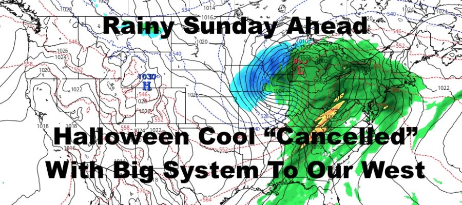
We’ll clear things out once again on Wednesday with a small window of sunshine, then increase the clouds again for another big system heading in for Halloween. This one is a game-changer in terms of the original forecast, but it’s also not something that wasn’t on our radar; it’s just happening 24hrs “late.”
It all came down to timing and the new timing is for that system to approach the area Thursday and Friday instead of Wednesday. Not all of Halloween looks like a rainout, but we’ll see those clouds continuing to increase, then maybe some afternoon rain. Since the system will be to our west, any cool/cold temps are “cancelled” and we should see upper 50’s to low 60’s.
Same goes for Friday which looks to be a complete rainout for now. Next weekend we’ll watch for the cool and blustery weather. However, with the high already established for some time, the air may be somewhat modified already and we may not be as cool as if our airmass moved in 2 days prior.
Our first frost or freeze is still possible, but if it happens it’ll be Friday night or Saturday night instead of Halloween night.
LOCAL RADAR PHILADELPHIA


MANY THANKS TO TROPICAL TIDBITS FOR THE USE OF MAPS
Please note that with regards to any tropical storms or hurricanes, should a storm be threatening, please consult your local National Weather Service office or your local government officials about what action you should be taking to protect life and property.