RELIEF FROM HEAT EVADES NYC IN THE IMMEDIATE FORECAST
 RELIEF FROM HEAT EVADES NYC IN THE IMMEDIATE FORECAST

RELIEF FROM HEAT EVADES NYC IN THE IMMEDIATE FORECAST – Good morning everyone! Probably around mid June or the 3rd week of June, I started talking about the signs of an extended period of above average and prolonged heat for the middle of July. The models were telling me I was wrong, but in my mind, the signs were still there, so I continued to discuss this prospect from then, all the way to a few days ago.
Well, it’s here and we’re going to be baking for a little while until relief can make its way down. However, relief is not on the immediate horizon. Not only that, but Saturday is looking closer to that 90 mark I was talking about, and Sunday is going to be hotter than expected. The models are doing some funky things, so I’m going to go into the immediate forecast for now.
Today, we’ll have clouds and sun, humid, with a slight chance of storms at any time in the afternoon and until sunset; highs in the upper 80’s. Tomorrow, we notch up the heat and humidity even more, with also a chance of some scattered afternoon storms; highs near 90 and maybe a few low 90’s in places. Thursday, we dry out a bit but remain hot, highs in the low 90’s as that high pressure I was talking about last week sinks to the far south and west, to give us westerly winds. We remain in the low 90’s on Friday, and we’ll watch for any storms riding over the edge of this ridge.
For the weekend, we will continue to watch for clusters of storms coming over the northern fringe of this egg-shaped ridge, but we will remain in the hot and humid sector. Highs on Saturday will be in the upper 80’s to near 90, then near 90 on Sunday with a few scattered low to mid 90’s in some of the notoriously warmer spots.
The heat continues on Monday, with highs again in the upper 80’s. Now this is where things get tricky; depending on the timing of a possible front, we could see upper 80’s to near 90 for one more day next Tuesday. The GFS model has an unseasonably cool core of air sinking into our area from the north, giving us highs in the low 70’s mid week next week. This COULD BE the sharp cold front I was talking about that could break this 10 day stretch of above normal temps and humidity, but it’s too early to tell because there are other signs that this cool core could push to our east before making its plunge. If this other scenario happened, it would cool down parts of New England, but keep us in the heat or at least seasonably warm and humid. However, if the GFS is right, we could see widespread severe weather in the Tri-State area with our first true strong cold front of the season.
While we have Tropical Storm Don working its way west, the Tropics overall remain quiet for any threats in our area. As stated last week, if high pressure set up where I thought it would, any tropical activity would be suppressed far south.
Stay tuned as we watch our extended heat unfold and any prospects of a break.
Satellite View

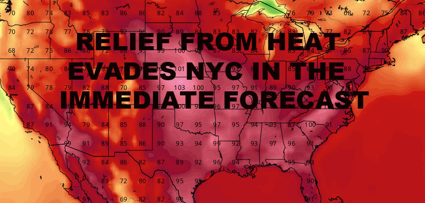
RELIEF FROM HEAT EVADES NYC IN THE IMMEDIATE FORECAST – Above average heat dominates for 6-7 more days on top of what we’ve already had. Then we look to the north for possible relief mid-week next week.
Northeast Radar

Radar is quiet , but a few scattered storms could pop up at anytime during the afternoon for almost the entire week as the sun interacts with high heat and humidity. As with yesterday, the majority of the action will be to our north and west. However, a few could sneak by the New York City area at any point.


NATIONAL WEATHER SERVICE SNOW FORECASTS
LATEST JOESTRADAMUS ON THE LONG RANGE
GET ANGRY BEN A NICE CIGAR!

Weather App

Don’t be without Meteorologist Joe Cioffi’s weather app. It is really a meteorologist app because you get my forecasts and my analysis and not some automated computer generated forecast based on the GFS model. This is why your app forecast changes every 6 hours. It is model driven with no human input at all. It gives you an icon, a temperature and no insight whatsoever.
It is a complete weather app to suit your forecast needs. All the weather information you need is right on your phone. Android or I-phone, use it to keep track of all the latest weather information and forecasts. This weather app is also free of advertising so you don’t have to worry about security issues with your device. An accurate forecast and no worries that your device is being compromised.
Use it in conjunction with my website and my facebook and twitter and you have complete weather coverage of all the latest weather and the long range outlook. The website has been redone and upgraded. Its easy to use and everything is archived so you can see how well Joe does or doesn’t do when it comes to forecasts and outlooks.
Just click on the google play button or the apple store button on the sidebar for my app which is on My Weather Concierge. Download the app for free. Subscribe to my forecasts on an ad free environment for just 99 cents a month.
Get my forecasts in the palm of your hand for less than the cost of a cup of Joe!
