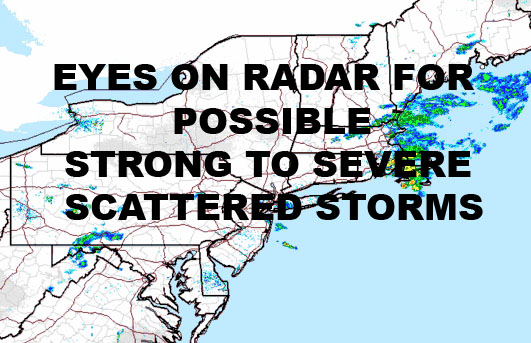
SCATTERED STRONG SEVERE NYC STORMS POSSIBLE TODAY
SCATTERED STRONG SEVERE NYC STORMS POSSIBLE TODAY
SCATTERED STRONG SEVERE NYC STORMS POSSIBLE TODAY – Good morning everyone! After some morning sprinkles, we have a hot, humid one ahead of us today. We’ll have sun and clouds and highs in the upper 80’s to near 90 today. Dew points are in the upper 60’s today, so with an area of energy passing by plus some sunshine here and there, we could see storms pop up at any point from mid-afternoon onward. The biggest threat with these storms will be torrential rain, frequent lightning, and gusty winds. However, anyone who does see a storm, especially upstate NY, northwest NJ, and parts of PA, could see some hail as well.
Because this boundary is weak, the heat will continue on for tomorrow and Thursday. That being said, things get real interesting for Thursday, especially in the late afternoon/evening, as we see a much stronger boundary entering the area with the help of a few waves of low pressure as well. This might very well spark off widespread showers and thunderstorms, plus a much broader area of severe weather compared to today. We’ll have upper 80’s on Wednesday, low to mid 90’s on Thursday, and near 80 on Friday; evidence of the difference between the two air masses and the concern for severe weather.
After we get past this, things return to normal for the weekend temperature-wise. Average temps are around 83 this time of year for the New York City area, and we should see temps in the low to mid 80’s over the weekend. Once we hit mid-week next week, we start to closely watch the prospect of some prolonged above average temps into the last 3rd of July. This all depends on the final position of where high pressure drifts and whether we get a Bermuda High-type set-up.
It doesn’t look like a textbook Bermuda High, it actually looks to try and set up a little further south and west. This would bring more WSW into the area as opposed to SSW winds. What would this mean for us if it happens? In Theory, we would get very warm to hot weather all the way to the immediate shore, and possibly a higher occurrence of nocturnal storms as energy travels around the edges of this ridge. We would also have to watch for a stronger than normal cold front once the ridge starts to collapse. It could approach on an angle that would be perfect for severe weather in the Northeast and all the way to the beaches. It would also suppress any would-be tropical systems well to our south, putting south Florida and the Gulf in the path should something develop. As of now though, there is nothing as far as immediate threats.
We’ll keep an eye on everything as it unfolds and watch for the heat, how long, and how it ends if it does come to fruition.
Satellite View
SCATTERED STRONG SEVERE NYC STORMS POSSIBLE TODAY – Waves of energy travel along a weak boundary, giving us the chance of some scattered storms today, then a better chance of some more widespread severe weather on Thursday.
NATIONAL WEATHER SERVICE SNOW FORECASTS
LATEST JOESTRADAMUS ON THE LONG RANGE
GET ANGRY BEN A NICE CIGAR!
Weather App
Don’t be without Meteorologist Joe Cioffi’s weather app. It is really a meteorologist app because you get my forecasts and my analysis and not some automated computer generated forecast based on the GFS model. This is why your app forecast changes every 6 hours. It is model driven with no human input at all. It gives you an icon, a temperature and no insight whatsoever.
It is a complete weather app to suit your forecast needs. All the weather information you need is right on your phone. Android or I-phone, use it to keep track of all the latest weather information and forecasts. This weather app is also free of advertising so you don’t have to worry about security issues with your device. An accurate forecast and no worries that your device is being compromised.
Use it in conjunction with my website and my facebook and twitter and you have complete weather coverage of all the latest weather and the long range outlook. The website has been redone and upgraded. Its easy to use and everything is archived so you can see how well Joe does or doesn’t do when it comes to forecasts and outlooks.
Just click on the google play button or the apple store button on the sidebar for my app which is on My Weather Concierge. Download the app for free. Subscribe to my forecasts on an ad free environment for just 99 cents a month.
Get my forecasts in the palm of your hand for less than the cost of a cup of Joe!


