

Weather in 5/Joe & Joe Weather Show Latest Podcast
Slow Moving Nor’Easter To Drop Locally Hefty Snow Amounts
Good morning everyone. Depending on where you live, we’re a few hours to 12-18hrs away from a long anticipated system. There was much to be worked out as far as track and fine tuning snow amounts, but I’m generally satisfied with what I see in order to give the final call. There is still some uncertainties, but most of those last minute questions come with every system, even the clear-cut ones, and we’ll discuss everything below.
SATELLITE

Clouds are here already, so we’re not going to increase them, we’ll lower and thicken them throughout the day. We could see some scattered flurries or light snow late, but the steadier snows hold off until later tonight. Highs today will be near 30.
Overnight, snows will get steadier and heavier, and anything that does fall will stick. Expect 1-3 inches by early morning, and then the bulk of the system heads in for tomorrow.
SNOW MAP – FINAL CALL
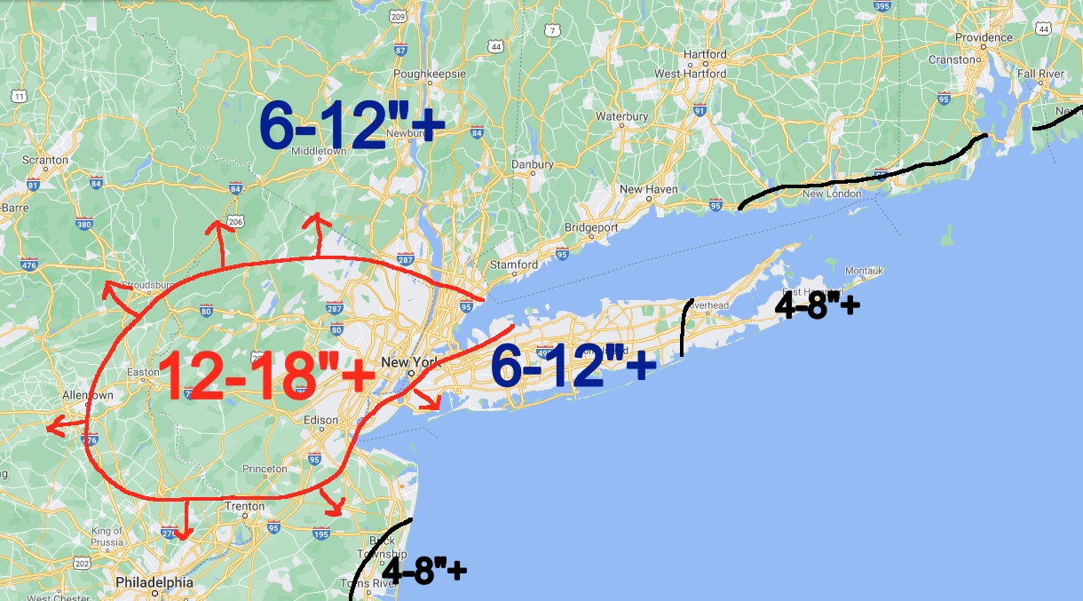
For the most part, this system is capable of a general 6-12″ snowfall in a large swath. However, slow movement and an earlier start in spots may affect the final outcome, which is why we put the “+”. There’s also a very small area of heavier convection that looks as if it’s going to form. Right now, the best chance of that happening looks to be in areas of NYC and west to parts of NJ. The area I depicted has arrows on it for a couple of reason. First and foremost, it’s impossible to predict where exactly that small area is going to set up and what size. The arrows represent any small shifts in direction or expanding that may occur. We also still have mixing to contend with in Eastern Suffolk and parts of the NJ coast. If that happens, totals will be knocked down compared to the rest of the region. We’re putting 4-8″+ with the “+” in case less mixing occurs.
For tomorrow, the bulk of the snow falls some time between late morning and afternoon. This will be the peak time and the worst commute if you happen to be on the road. Some time late evening, snow will become lighter in nature, then become spotty through tomorrow with on and off light to moderate snow.
Again, on a scale of Nor’easters in terms of strength, this is a 1 to 2 out of 10, 10 being the worst. It’s the slow movement that is the issue here. Wind gusts won’t be impressive on this one, and you’ll get your staple 35-45mph wind gusts near the immediate shore, and some gusty conditions away from the shore.

Wednesday will be a good cleanup day, with highs in the mid 30’s and sunny skies. Thursday will help things along, with near 40 temps and sunny skies again.
Our next system is a rainmaker, with some rain heading in late week into early this weekend. Highs in the mid 40’s.

BE SURE TO DOWNLOAD THE FREE METEOROLOGIST JOE CIOFFI WEATHER APP &
ANGRY BEN’S FREE WEATHER APP “THE ANGRY WEATHERMAN!
MANY THANKS TO TROPICAL TIDBITS FOR THE USE OF MAPS
Please note that with regards to any severe weather, tropical storms, or hurricanes, should a storm be threatening, please consult your local National Weather Service office or your local government officials about what action you should be taking to protect life and property.