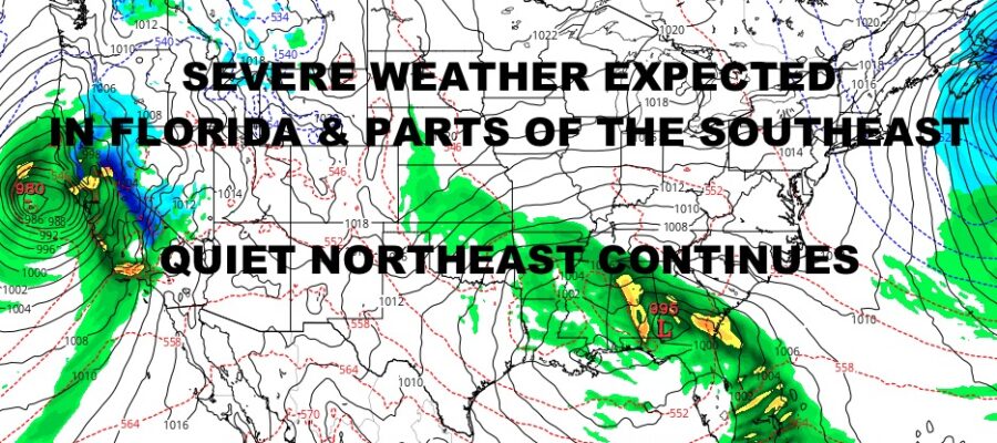
Stormy Southeast Quiet Northeast
Good morning everyone. As expected, we are watching low pressure generate enough lift and turbulence in the atmosphere to spark off concerns about severe weather and tornadic activity.
This activity is ahead of a wave of low pressure developing in the Gulf of Mexico that’ll meander in the Southeast and slowly move into the Atlantic as time goes on. As we move through the next 24-48hrs, heavy showers and locally severe weather will erupt and then fizzle; then erupt again with each spoke of energy and sunshine.
We’ll also watch closely the north Florida coast, coastal Georgia, and coastal South Carolina for the possibility of severe storms later this afternoon and tonight. For now, the focus will be the West Coast of Florida, then lower Central/South Florida for severe weather. After we shift from here to the Southeast Coast, then we will shift back to South Florida and the Keys for another chance of some severe thunderstorms tomorrow morning.
With any of these storms, aside from isolated tornado activity, look for the possibility of large hail, frequent lightning, strong gusty winds, and torrential rain.
Once low pressure heads offshore, we will watch for the wind, high surf, and enhanced tide component. As of now, minor coastal flooding is possible in parts of South Carolina. North Carolina, the East Coast of Florida, and parts of Georgia Tuesday & Wednesday.
Stay tuned and we will watch this situation closely. Here is your local forecast –
SATELLITE

We’re going to keep it very simple since it’s a Sunday and we have nothing notable for the workweek. Look for sunshine today through Thursday, with some extra clouds Friday as milder air heads in. Highs today and tomorrow will be int he mid 40’s, then we’ll dip a bit on Tuesday near 40. Look for a return to mid 40’s Wednesday, then mid to upper 40’s Friday.
WEATHER RADAR

We’ll have sun and clouds both Saturday and Sunday, with 55-60 degree temps Saturday; then we dip a bit into the low 50’s Sunday w/ the slight chance of a shower.

BE SURE TO DOWNLOAD THE FREE METEOROLOGIST JOE CIOFFI WEATHER APP &
ANGRY BEN’S FREE WEATHER APP “THE ANGRY WEATHERMAN!
MANY THANKS TO TROPICAL TIDBITS & F5 WEATHER FOR THE USE OF MAPS
Please note that with regards to any severe weather, tropical storms, or hurricanes, should a storm be threatening, please consult your local National Weather Service office or your local government officials about what action you should be taking to protect life and property.