Unseasonably Cold Night Across New York City Area
Good morning everyone. We have a nasty start to the day here and even with rain departing by late morning/early afternoon, temperatures will struggle to recover as a chilly push of air settles over the area. We’re also expecting an unseasonably cold night not only across our area, but down to the Mid-Atlantic, Southeast, and along the Gulf States.
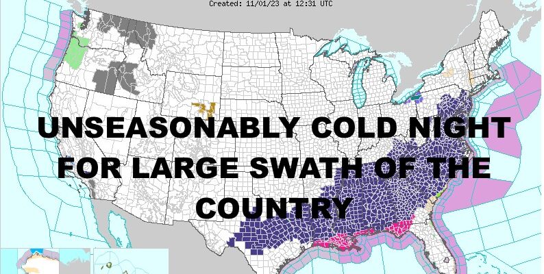
Frost and freeze warnings are posted throughout 25%+ of the lower 48, but that doesn’t mean we’re the only ones experiencing the cold. Typically, once an area has a hard freeze, the warnings aren’t posted again. So these areas you see for the most part, are the ones experiencing this cold push for the first time. Areas behind the watches and warnings are going to be very cold as well.
Overall, this shows us how much cold air is available if the jet stream cooperates in a bad way. This also means that November could be very interesting as far as some early season snows for parts of the Northeast if a perfectly-timed system happens to catch the dragon’s tail in terms of cold air.
SATELLITE

For today, expect light rain continuing until late morning/early afternoon. We’re stuck in the low 40’s right now and depending on when partial clearing occurs, we’ll either be stuck in the low 40’s, or see some mid 40’s. That’ll be it for today with a being breeze developing as well. Lows overnight will dip into the low to mid 30’s for the NYC area, and 30-35 for the Long Island area. For the Pine Barrens of Long Island, we could see some 20’s if conditions are right as far as lack of clouds and lighter winds. N&W of the NYC area, 20’s will be more common.
Tomorrow we modify a bit with some extra sunshine and lighter winds. Look for highs in the upper 40’s to near 50, then we have another cold one overnight.
WEATHER RADAR

For Friday, we graduate into the mid to upper 50’s, then nighttime lows become more tolerable with 40’s expected overnight in NYC.
Your weekend remains looking like early November perfection, with sunshine and low 60’s. We could see a few mid 60’s if the wind cooperates.

Low to mid 60’s want to continue into early next week, but then we begin to watch our next big system and the timing of that. We could see another plunge in temps Wednesday or Thursday, but we remain on a 1-2 day margin of error on this for the moment.
BE SURE TO DOWNLOAD THE FREE METEOROLOGIST JOE CIOFFI WEATHER APP &
ANGRY BEN’S FREE WEATHER APP “THE ANGRY WEATHERMAN!
MANY THANKS TO TROPICAL TIDBITS & F5 WEATHER FOR THE USE OF MAPS
Please note that with regards to any severe weather, tropical storms, or hurricanes, should a storm be threatening, please consult your local National Weather Service office or your local government officials about what action you should be taking to protect life and property.