
WARM WINTER NYC TUESDAY

WARM WINTER NYC TUESDAY
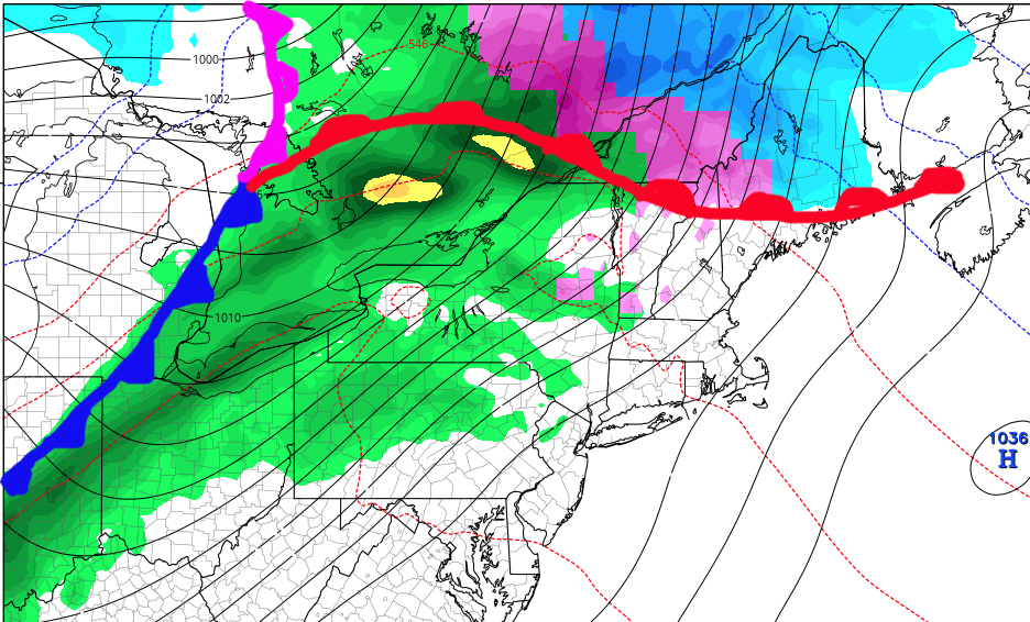
WARM WINTER NYC TUESDAY – Good afternoon everyone, hope everyone had a great holiday weekend! Let’s jump right into the forecast as we have lot’s to talk about. First off, a warm front is off to our north and west as we speak, spreading clouds, a damp breeze, and widely scattered light showers into the area. As the front passes well to our north, expect temperatures to rise overnight. After a period of some steady light rain, don’t be surprised if temps are in the low 50’s by the time you wake up tomorrow morning! Tomorrow, rain associated with a cold front will move into the area, giving us the possibility of a short period of moderate to heavy rain before noon. Highs will reach near 60 tomorrow, before dropping after the front passes and the sun returns. Wednesday will be sunny and seasonably cool, with highs in the low to mid 40’s as we sit between two systems once again.

WARM WINTER NYC TUESDAY – After a warm start to the week, Wednesday’s much cooler weather will set us up for some wet flakes mixed with rain Thursday morning as another system approaches. For the NYC area, I don’t expect a big deal by any means. However, areas north and west may see a cheap thrill that would equate into possibly a difficult commute if you commute to NYC in the morning. Give yourself some extra time and stay tuned for updates since scenarios change quickly, especially “onset snows” with the approach of systems. Any frozen precip turns to all rain by late morning, with highs in the mid to upper 40’s, and colder air is reinforced temporarily for the start of New Year’s weekend. Friday and Saturday will both be seasonably cold, with highs in the mid to upper 30’s and lows in the upper 20’s to low 30’s, so bundle up if you’re heading out to go see the ball drop at Times Square for New Years.
Sunday we watch another warm/cold front combo approach and the possibility of 1-2 days of above normal temps depending on the final track of this system. Stay tuned as we watch this, as well as the prospect of some more arctic air moving in during the next 7-10 days.

WARM WINTER NYC TUESDAY – Radar is showing some echoes in the form of widely scattered showers associated with a warm/cold front combo heading into our area. A warm day tomorrow before the cold front passes by and brings us back to reality.

FiOS1 News Weather Forecast For Long Island
FiOS1 News Weather Forecast For New Jersey
FiOS1 News Weather Forecast For Hudson Valley
NATIONAL WEATHER SERVICE SNOW FORECASTS
LATEST JOESTRADAMUS ON THE LONG RANGE

Weather App

Don’t be without Meteorologist Joe Cioffi’s weather app. It is really a meteorologist app because you get my forecasts and my analysis and not some automated computer generated forecast based on the GFS model. This is why your app forecast changes every 6 hours. It is model driven with no human input at all. It gives you an icon, a temperature and no insight whatsoever.
It is a complete weather app to suit your forecast needs. All the weather information you need is right on your phone. Android or I-phone, use it to keep track of all the latest weather information and forecasts. This weather app is also free of advertising so you don’t have to worry about security issues with your device. An accurate forecast and no worries that your device is being compromised.
Use it in conjunction with my website and my facebook and twitter and you have complete weather coverage of all the latest weather and the long range outlook. The website has been redone and upgraded. Its easy to use and everything is archived so you can see how well Joe does or doesn’t do when it comes to forecasts and outlooks.
Just click on the google play button or the apple store button on the sidebar for my app which is on My Weather Concierge. Download the app for free. Subscribe to my forecasts on an ad free environment for just 99 cents a month.
Get my forecasts in the palm of your hand for less than the cost of a cup of Joe!
