Coastal System Brings Heavy Rain to NYC Saturday
03/20/24 8:00am ET
Good morning everyone. We continue to watch several features on the map that are bringing unseasonably cold to chilly air in areas that are typically in full spring right now; plus a wave of low pressure that will bring some flooding rains to parts of Florida and heavy rain/wind into the Northeast.
Overnight tonight, unusually late-season frost is expected in areas of Georgia, Alabama, and even into the Panhandle of Florida. Cold air continues to be stubborn, and will re-infiltrate the Northeast overnight as well, spreading mid to upper 20’s all the way to the coast.
We’ll also begin to watch the genesis of our next system, which will spawn heavy rain and thunderstorms across the Texas and Louisiana coast tomorrow; then spread east across the rest of the Gulf States and on into Florida. Florida will bear the biggest brunt of our developing low pressure system, with flooding rain and heavy thunderstorms expected; especially on the West Coast and south Florida. Embedded severe weather is a possibility as well, with isolated large hail, waterspouts, and isolated tornadoes possible. The timeline remains Friday into Friday night for heavy rain snd storms.
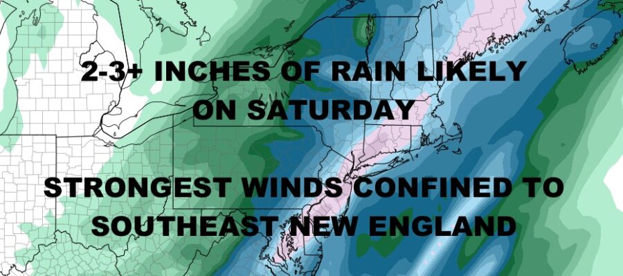
All that mess slides up the Southeast coast early Saturday, then reaches the Northeast by mid to late Saturday. Expect 2-3″+ of heavy rain, with 40-50mph gusts possible along the southeast New England coast; especially Cape Cod, Nantucket, and Martha’s Vineyard.
Your local NYC forecast is below –
SATELLITE

We’re starting off nice here in NYC, but a reinforcing shot of cold air will bring the chance of some scattered showers this afternoon. Look for highs in the mid 50’s today, then unseasonably cold overnight with mid to upper 20’s.
WEATHER RADAR

Cold air locks in tomorrow with low to mid 40’s at best, sunshine, a stiff breeze, and lows dipping back into the 20’s overnight. Winds relax on Friday, but we remain chilly with mid to upper 40’s.

Expect on and off heavy rain on Saturday with near 50 temps and a developing breeze. Winds along the NYC/LI coast could gust 25-40mph depending on when that low begins to deepen. Things clear out Sunday for a chilly and breezy day in the mid to upper 40’s.
BE SURE TO DOWNLOAD THE FREE METEOROLOGIST JOE CIOFFI WEATHER APP &
ANGRY BEN’S FREE WEATHER APP “THE ANGRY WEATHERMAN!
MANY THANKS TO TROPICAL TIDBITS & F5 WEATHER FOR THE USE OF MAPS
Please note that with regards to any severe weather, tropical storms, or hurricanes, should a storm be threatening, please consult your local National Weather Service office or your local government officials about what action you should be taking to protect life and property.