East Coast Winter Storm Begins to Take Shape
Good afternoon everyone. Our winter storm expected this weekend is beginning to take shape out west as the ingredients are starting to come together. Meanwhile the first piece of the puzzle; a disturbance moving through here along with energy well-offshore, is on schedule and doing its thing with a broken line of snow showers moving through the Northeast. That’ll help reinforce the cold air as our system moves in.
How much cold air will be part of the puzzle, as well as how strong our system gets. As stated in previous articles, a weaker storm means more rain. A stronger storm could help keep or reintroduce cold air into the system, increasing the real estate of our swath of snow; and snow amounts as well. In general, we’ve been saying that this system is capable of 4-8″ or 6-12″ snowfalls (with locally higher amounts) depending on its strength.
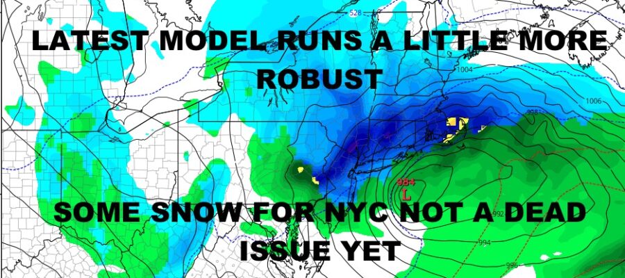
Our latest model run on the GFS shows a more robust system that could help those snow lovers in the New York City area by keeping a glimmer hope for some accumulating snow. A stronger system and a difference of 40-60 miles, could mean the difference between rain and mixed precip, to rain changing over to heavier snow before departing. As of this moment, we will keep the biggest accumulations expected, to the confines of eastern and northeastern PA, Northwest NJ, the lower Hudson Valley of NY, and parts of lower New England. This is where we will most likely see that 4-8 or 6-12″ swath of snow, with even bigger amounts if some stronger convection sets up.
There is still time for wiggle room in either direction in terms of rain/snow lines, strength, and total snow accumulations. We’re at Thursday now for a Saturday storm.
Here is your local forecast –
SATELLITE

Clouds stick around for most of the day as our reinforcing hit of cold air moves in. We’ll have the slight chance of some scattered flurries, graupel, or light sprinkles. Highs will be in the low 40’s with maybe a blue break here and there late.
We’ll have full sunshine tomorrow, but it’ll be breezy and cold. Highs will be in the mid 30’s, maybe a few upper 30’s here and there.
WEATHER RADAR

Clouds increase on Saturday with the chance of some light rain and/or snow as the day wears on. High will be 35-40. Precipiation will become steadier and heavier overnight with winds increasing. Look for rain, mix, and/or snow on Sunday, possibly ending as all snow. Highs on Sunday in the mid to upper 30’s, possibly slightly colder if that storm is stronger and in a better position.
Whatever does happen, expect icy conditions overnight Sunday and for your commute Monday morning as anything wet freezes with lows in the 20’s.

BE SURE TO DOWNLOAD THE FREE METEOROLOGIST JOE CIOFFI WEATHER APP &
ANGRY BEN’S FREE WEATHER APP “THE ANGRY WEATHERMAN!
MANY THANKS TO TROPICAL TIDBITS & F5 WEATHER FOR THE USE OF MAPS
Please note that with regards to any severe weather, tropical storms, or hurricanes, should a storm be threatening, please consult your local National Weather Service office or your local government officials about what action you should be taking to protect life and property.