Hurricane Laura Intensifies Into Major Hurricane, NYC Gets Taste Of Early Fall
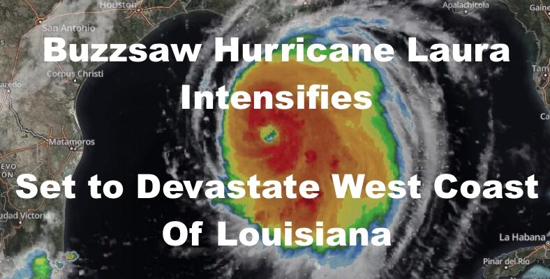
Good morning everyone. We continue to watch the Gulf of Mexico in regards to Hurricane Laura. Currently, she’s clocking in with 115+ mph winds and expecting to intensify even further before making landfall just east of the LA/TX coastal border.
Thankfully it’s a very sparsely populated coastal region, but small farming towns such as Oak Grove and Grand Chenier, could essentially be wiped off the map. Then we’ll have to see if Lake Charles, LA, which sits about 7-10 miles inland, can absorb her wrath. They will not be spared the surge, since they sit on Calcassieu Lake/River, which connects to the Gulf via the bayou. Catastrophic storm surge and destructive winds are expected by 12am tonight, which makes it even more important to evacuate immediately to avoid an overnight tragedy and loss of life.
SATELLITE

As for us here, we are enjoying a brief moment of cooler Canadian high pressure, with sunny skies, low humidity, a stiff breeze, and highs today 75-80.
REGIONAL RADAR

Overnight tonight, a warm front is going to make a pass with temps only dropping down to near 70 after high in the 70’s. During its pass, we could see some showers and embedded storms.
Hot air is back tomorrow before a backdoor front drops through. We’ll be playing this game as the front passes by, drops down, passes by, then finally leaving with Laura some time on Saturday. However tomorrow, we could see some severe storms with this first pass of the front. It’ll be a humid, near 90 day, then we keep an eye to the sky in the afternoon.
Back door fronts are tricky when trying to predict how it’ll go since storms are moving north to south or even northeast to southwest, but we’ll take it as it comes and keep an eye on the radar.
LOCAL RADAR NEW YORK CITY

For Friday and Saturday, that front lingers in the area, with Friday being the better of the two days. Expect sun and clouds, mid 80’s, and the slight chance of a storm.
The chance of showers and storms increases Saturday with Laura’s remnants passing to our south, and it’ll be a cloudy and muggy day overall with low to mid 80’s.
LOCAL RADAR PHILADELPHIA


Sunday and Monday remain looking gorgeous, with 75-80 degree temps, low humidity, sunny skies, and breezy conditions.
Getting near or at Labor Day Weekend, things remain in place for possibly our last 2-3 day taste of 90’s in a row. We’ll be keeping an eye out for the timing of our next cold front, and that could split the holiday weekend up temp-wise, and also give us an enhanced risk of severe weather at some point.
MANY THANKS TO TROPICAL TIDBITS FOR THE USE OF MAPS
Please note that with regards to any tropical storms or hurricanes, should a storm be threatening, please consult your local National Weather Service office or your local government officials about what action you should be taking to protect life and property.