NYC Severe Weather Possible Today Comfortable Temps Tomorrow
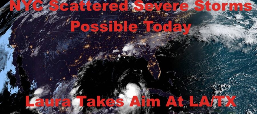
Good morning everyone. The Gulf Coast caught a major break yesterday as Tropical Storm Marco essentially fizzled into nothing after reaching hurricane-status. Now we await to see what Laura has up her sleeve as she aims for the LA/TX coastal border. For us, we have a wide array of weather ahead, plus the remnants of Laura before much cooler air settles in.
SATELLITE

We’re starting off sunny this morning, but clouds will begin to move in ahead of our next cold front. This one could spark off some scattered severe weather in the Tri-State area. Not everyone will see action, but for those who do, prepare for the possibility of damaging winds, hail, frequent lightning, torrential rain, and maybe even an isolated tornado. Highs today will be in the low 90’s with high humidity.
REGIONAL RADAR

Tomorrow we turn things around with bright sunshine, a cool breeze, low humidity, and highs near 80. However, it doesn’t last long with very warm to hot conditions fighting back.
Clouds and sun, increasing humidity, and upper 80’s to near 90 return for Thursday, and we’ll have the slight chance of a storm. The “best” of the slight chance will be in interior sections of the Northeast and New England.
LOCAL RADAR NEW YORK CITY

Friday and Saturday, we’ll be watching closely to see what-will-be Hurricane Laura does in terms of her remnants. At minimum, our next cold front will drape itself across the area, giving us an increased chance of showers and storms. Laura will ride up the Mississippi valley and then get caught up by the front. That may enhance the rain for Saturday, giving us the chance of some flooding in poor drainage spots, but she’s in and out of the area very quickly. Don’t expect a replay of our last tropical system, and Laura will not have the ability to do that level of tree damage/power outages.
Expect highs in the mid 80’s and very muggy Friday, then a muggy low to mid 80’s Saturday as clouds dampen the temps a bit.
LOCAL RADAR PHILADELPHIA


Sunday and Monday look to be refreshingly cool for this time of season, with breezy conditions, low humidity, bright sunshine, and highs 75-80 both days. Some areas well N&W of the City may not get out of the low 70’s for highs and the air at night will be relatively crisp.
In the long range, I don’t think we’re done with the heat yet, but things are on the move and nothing lasts long this time of year when systems are moving fast. Our next chance of near 90 temps looks to be some time around Labor Day weekend, but not throughout the entire weekend. At some point, another strong cold front is going to swing by, but it’s too far out to nail down the exact timing yet. For the moment, look for a split holiday weekend in terms of temps, with a mix of hot temps possible, then cool & comfortable.
MANY THANKS TO TROPICAL TIDBITS FOR THE USE OF MAPS
Please note that with regards to any tropical storms or hurricanes, should a storm be threatening, please consult your local National Weather Service office or your local government officials about what action you should be taking to protect life and property.