JUNE GLOOM START LONG ROAD AHEAD PATTERN WISE
JUNE GLOOM START LONG ROAD AHEAD PATTERN WISE
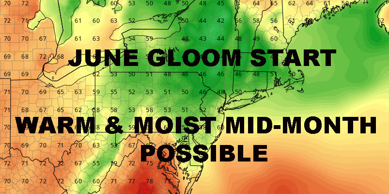
JUNE GLOOM START LONG ROAD AHEAD PATTERN WISE – Good morning everyone. Welcome to day 187 of the gloom on top of gloom and there’s no relief in sight. A stubborn pattern has locked itself into the eastern half of the Nation and aside from the tropical threat in the south, NYC and the Northeast is taking the brunt of this pattern.
As we speak, an approaching warm front is bringing with it clouds, showers, and areas of fog. We start off cool, showery, and cloudy, then we should catch a break by mid-morning. Look for clouds and sun late, chance of a few showers and/or rumbles of thunder, highs a humid 75-80.
Fog rolls back in tonight, then we’ll have a another mostly cloudy to all cloudy day tomorrow. We may approach 80 again tomorrow, but we’ll do so with the threat of late morning to early afternoon showers and storms. Not everyone is going to see rain and it won’t be a complete rainout, but for those that do find themselves in the rain shield, it’s not going to be a good day for outdoor activities. We’ll try and pinpoint exactly where that sets up tomorrow early AM.
On Sunday, we try and clear out, but the east wind returns and it may be gusty, especially at the immediate shore. Expect clouds and sun, upper 60’s to low 70’s, and a cool feeling, gusty day. No beach day on Sunday with that easterly gust, rip tides and rough conditions will be raging.
As we enter next week, clouds and showers return as expected. Again, no rainouts, but the threat of rain will be with us for another 2 day block. Clouds and showers on Monday, unseasonably cool, highs in the low 60’s at best. Same for Tuesday, highs in the mid 60’s at best. We play the game again mid-week, with sun and clouds once again, easterly winds once again, and low 70’s once again.
It’s going to be hard to break this pattern unless something significant comes along to give the jet stream a good jolt. If that doesn’t happen, we have to wait for it to fizzle out on it’s own, which could take weeks. What we can only hope for right now, is a slight shift in the pattern, maybe a couple of hundred miles north. If we can pull this off, the pattern itself would remain; but we’ll be cloudy, warm/very warm, and rainy, instead of cloudy, cool, and rainy.
EASTERN SATELLITE

REGIONAL RADAR

LOCAL RADAR NEW YORK CITY

LOCAL RADAR PHILADELPHIA


 GET JOE A CIGAR IF YOU LIKE
FiOS1 News Weather Forecast For Long Island
FiOS1 News Weather Forecast For New Jersey
FiOS1 News Weather Forecast For Hudson Valley
NATIONAL WEATHER SERVICE SNOW FORECASTS
LATEST JOESTRADAMUS ON THE LONG RANGE