Nasty Weather Expected in NYC Tomorrow
05/09/24 11:35am
Good morning everyone. We had a violent afternoon and night last night severe-weather-wise in the Lower Plains and Southeast yesterday; and now that severe weather has sunk further into the Southeast. We’re watching tornado watches posted in areas of Alabama, Georgia, and South Carolina that are set to expire in the afternoon.
We’ll watch and see if these storms can hold together or not, but regardless, look for severe weather in these areas for the next few hours. While we haven’t seen any tornado warnings in the past hour or so, we have seen severe thunderstorm warnings. Some of these storms have a history of large hail, frequent lightning, and damaging winds. Do not let your guard down as any of these individual cells could spawn a tornado.
Storms are expected to continue to move to the east, southeast, and south, then possibly re-fire this afternoon in smaller, but just-as-powerful lines. In the late evening and overnight hours, we’re also expecting scattered storms to develop in parts of Louisiana, get better organized, then trudge through Mississippi, Alabama, and Georgia in a compact, but powerful line. Expect large hail, damaging winds, and isolated tornadoes with this nocturnal thunderstorm complex.
Please stayed tuned to your local agencies of the latest watches and warnings. Here is your local NYC Metro forecast –
SATELLITE

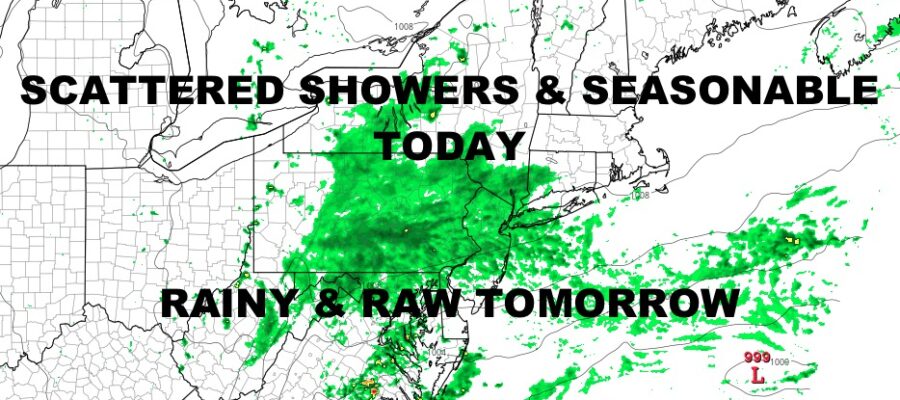
We have a morning mix of sun, clouds, and showers in the NYC area, but majority clouds will be the name of the game as the day wears on. Look for highs in the upper 60’s to low 70’s.
Tomorrow is simply an awful day, with clouds, showers, and damp conditions. Highs will barely make it into the upper 50’s for a nasty May day.
WEATHER RADAR

Your weekend isn’t looking that fantastic either. Saturday is the best day of the 2, with sun & clouds and late scattered showers. Highs in the low 60’s. Showery and raw conditions return on Sunday with more 50’s expected.

Things clear out on Monday with a typical spring day in NYC and a night start to your workweek. Highs will be in the low 70’s for a very seasonable day.
BE SURE TO DOWNLOAD THE FREE METEOROLOGIST JOE CIOFFI WEATHER APP &
ANGRY BEN’S FREE WEATHER APP “THE ANGRY WEATHERMAN!
MANY THANKS TO TROPICAL TIDBITS & F5 WEATHER FOR THE USE OF MAPS
Please note that with regards to any severe weather, tropical storms, or hurricanes, should a storm be threatening, please consult your local National Weather Service office or your local government officials about what action you should be taking to protect life and property.