NYC Cloudy Rainy Period Starts Tomorrow
Good morning everyone. Things are quiet in the Northeast as winds have subsided and temperatures begin to modify. We go milder starting tomorrow, but rain moves in from the southeast; where heavy showers and thunderstorms are moving through Alabama, Mississippi, and Georgia as we speak. No severe weather is expected there today, but we could see some flooding in poor drainage areas, and some cloud-to-ground lightning where there are some embedded heavy storms.
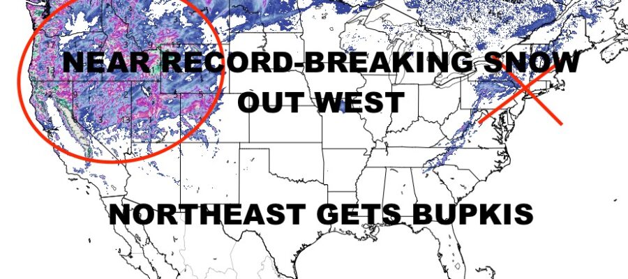
Clouds stick around after rain moves through in the Northeast, but we go fairly mild for a few days ahead of the next system midweek next week. That system is our big story of the day, not for the Northeast, but for the West. Near-record-breaking snows are expected as Blizzard Warnings have been posted along the Sierra-Nevada range, and Winter Storm Warnings posted throughout the other ranges in the Northwest & Rockies. In some locales, more than 8ft of snow may fall in under 48-72hrs, while some mountain passes could see 100+ mph winds. This is a serious storm that will add onto an already-epic base of snow that’ll be sure to help refill some of the reservoirs come spring and summer.
Here is your cloudy local NYC Metro Forecast –
SATELLITE

Sunshine rules the roost today with chilly conditions, but lighter winds. Highs in the 40-45 range. Clouds increase overnight, and expect on and off rain tomorrow with near 50 temps. Some of these showers may be moderate to heavy at times. We dry out on Sunday, but clouds stick around for a cloudy and midl day. Highs will be 55-60 depending on if we get any blue breaks.
WEATHER RADAR

The same goes for Monday with clouds and highs near 60 depending on what little sunshine we get. If we do see some extra sunshine, we could pop past 60 for a couple of hours. Cloud stick around on Tuesday as well, with 55-60 degree temps and the same story. Wednesday we’ll watch for some rain, but the best chance will be overnight Wednesday into Thursday with mid 50’s each day.

We clear out temporarily on Friday with some wind and cooler temps, then rain returns some time next weekend.
BE SURE TO DOWNLOAD THE FREE METEOROLOGIST JOE CIOFFI WEATHER APP &
ANGRY BEN’S FREE WEATHER APP “THE ANGRY WEATHERMAN!
MANY THANKS TO TROPICAL TIDBITS & F5 WEATHER FOR THE USE OF MAPS
Please note that with regards to any severe weather, tropical storms, or hurricanes, should a storm be threatening, please consult your local National Weather Service office or your local government officials about what action you should be taking to protect life and property.