NYC Flash Flooding Likely In Spots That See Heavy Showers Storms
Good morning everyone. Clouds have arrived as have that scattered heavy showers and storms with our frontal boundary slowly pushing east. As stated yesterday, that majority of the heaviest action will remain to our north and west, but the NYC definitely gets into the action today. We also have the risk of flooding, especially in NW NJ and upstate NY, and NYC could get into that action as well if storms form and reform over the area. Things will begin to quiet down on Tuesday, and we have a hot to very hot Wednesday ahead.
SATELLITE

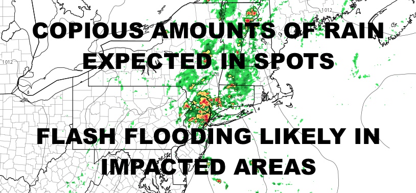
Don’t expect much sun today and keep an eye on the radar. That’s going to be the name of the games as heavy showers and heavy thunderstorms can for and drift over the area at any time during the day. As our wave gets more organized, we could see a more concentrated batch of heavy showers and storms slam NW NJ and the lower Hudson Valley; and the southern edge of that action could reach down into the NYC area and Long Island. Flash flooding will be widespread in spots impacted the most. Highs today will be a muggy low 80’s.
For tomorrow, we have some leftover energy which will give us the risk of more AM showers and heavy storms. Highs remain a juicy 80-85 degree depending on when the rain departs.
WEATHER RADAR

Sunshine returns on Tuesday with the slight chance of an isolated PM storm. It’ll be a very warm to hot one, with highs in the upper 80’s to near 90.
Wednesday will be the hottest day of the bunch, with increasing humidity and highs 90-95.

Heat and humidity stick around for Thursday, but we settle back into very muggy conditions with near 90 temps and the slight chance of a PM Storms. For Friday, look for more of the same and a better chance of a thunderstorm or two.
BE SURE TO DOWNLOAD THE FREE METEOROLOGIST JOE CIOFFI WEATHER APP &
ANGRY BEN’S FREE WEATHER APP “THE ANGRY WEATHERMAN!
MANY THANKS TO TROPICAL TIDBITS & F5 WEATHER FOR THE USE OF MAPS
Please note that with regards to any severe weather, tropical storms, or hurricanes, should a storm be threatening, please consult your local National Weather Service office or your local government officials about what action you should be taking to protect life and property.