NYC Four Day Rain Event Begins
04/01/24 9:12am ET
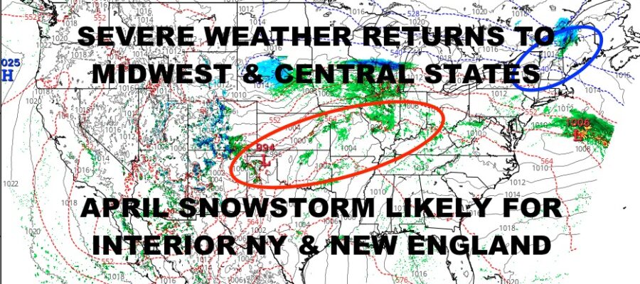
Good morning everyone and welcome to the gloomy part of the programming. We are watching our “daisy-chain” system stretch from Rockies to the East Coast, and this will eventually become a big player in the Northeast & New England for a monster April snowstorm.
We are slowly watching the ingredients come together for rare 18-24″ snows in parts of interior New York State, interior New England, and possibly stretching to coastal Maine; but for now, the big story is the emerging threat of severe thunderstorms across the Panhandle of Texas, Oklahoma, Kansas, Missouri, Illinois, Indiana, and possibly into Ohio this afternoon through tomorrow late morning from southwest to northeast.
We’ll watch for our low pressure to emerge from the Rockies late this morning, then the sun will help work the atmosphere in the Panhandle of Texas to start firing off those storms. This will not be one big squall line that will move in linear fashion across the states, but more like roving clusters that’ll fire up, burn out, and reform. Aside from the usual conditions that come with thunderstorms, we’re expecting tornadoes with some of these, as well as large hail in spots.
As low pressure enters Michigan, a second wave will begin to form somewhere near western Tennessee. When that does, we will see more severe weather fire up in Tennessee itself, stretch across Mississippi and Alabama, then chug on east into Georgia/South Carolina, and into Florida from late in the evening tomorrow through Wednesday afternoon west to east/southeast. This line of storms will be different than the clusters we see across the Midwest and Central States. While large hail and isolated tornadoes are possible, damaging straight-line winds will be the main threat.
While this line passes, we will see low pressure race northeast and slam into colder air wedged into New England. As low pressure redevelops and straightens, it’ll lock that cold air in, pull it back west into interior New York, and generate a large swatch of extremely heavy snow from central Upstate NY on into interior parts of New England. The timeline on this chapter looks to be Wednesday night into Thursday evening as far as the heaviest precip, then things will begin to taper off to light snow. Don’t be surprised that we see some blizzard warnings out of this depending on the final setup and strength of low pressure.
Here is your local NYC Metro forecast –
SATELLITE

We’re going to keep things simple here as far as clouds and rain. Look for on and off rain today and tomorrow, with highs in the near 50/low 50 range.
WEATHER RADAR

Steadier and heavier rain pays a visit Wednesday through Thursday afternoon, with wind developing and raw conditions. Highs in the mid to upper 40’s.
We could see a wet snowflake or two mixed in with the rain as everything ends, but no accumulation is expected here in NYC or Long Island.

The sun returns on Friday with blustery conditions and highs 45-50.
BE SURE TO DOWNLOAD THE FREE METEOROLOGIST JOE CIOFFI WEATHER APP &
ANGRY BEN’S FREE WEATHER APP “THE ANGRY WEATHERMAN!
MANY THANKS TO TROPICAL TIDBITS & F5 WEATHER FOR THE USE OF MAPS
Please note that with regards to any severe weather, tropical storms, or hurricanes, should a storm be threatening, please consult your local National Weather Service office or your local government officials about what action you should be taking to protect life and property.