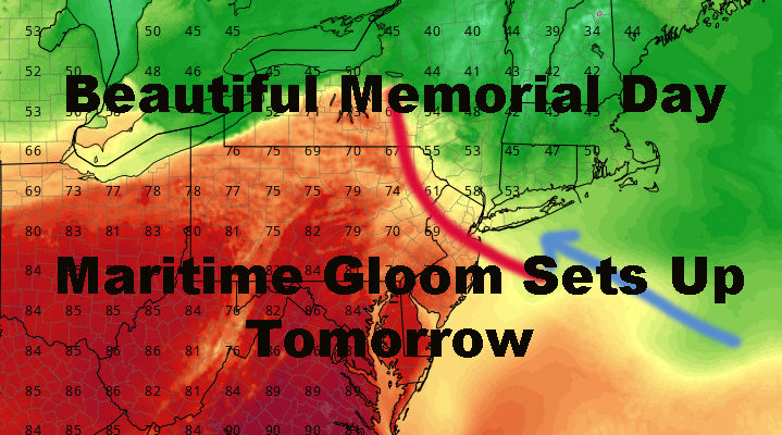
NYC Gloom Returns After Beautiful Memorial Day
Good morning everyone. We have a beautiful Memorial Day in store for us in the New York City Metro Area today, but some change is in the air. Our pattern remains an active one, but went unnoticed because we essentially walked through most of the clouds and raindrops overnight. Now we shift a little bit and will see some daytime activity.
SATELLITE

Plain and simple, we have a gorgeous and sunny day today. A light but steady northerly flow will keep things seasonably mild, with comfortable and dry conditions; highs 75-80 in most spots.
REGIONAL RADAR

Overnight tonight, the clouds hold off, but our winds go south, then eventually southeast; which is not good news. Highs pressure will slide off the coast and start pumping in some maritime air. Clouds will lower and thicken with an area of disturbed weather dropping in from the Great Lakes.
The two ingredients will combine for a cloudy, raw, and showery afternoon tomorrow. The rain won’t be constant, but a continuous breeze pushing in from the cool water and thick cloud bank, will keep us down big-time compared to the last few days. All in all, we’ll be lucky if we get into the low 60’s with scattered showers hanging around.
LOCAL RADAR NEW YORK CITY

We settle down a bit on Wednesday and modify the temps back towards average, but pieces of energy from a weak system well out to our west, will continue to ride up and over that stubborn ridge in the southeast. What that means for us will be the threat of a fews showers on any given day, at any given time.
Expect sun and clouds Wednesday, a chance of a shower at any time; highs in the low to mid 70’s. If we get a little bit of extra sunshine, we could modify that forecast into a 75-80 type day. Same goes for Thursday, but the ridge nudges up a bit as does the flow of energy over us. That’ll pave the way for some warmer air creeping in, but we keep the chance of a shower with sun and clouds in the area; highs in the mid 80’s possible.
For Friday, theres a chance we dry out and introduce more sun temporarily into the NYC area. If we do this, expect a sun-filled, rain-free day, with highs 80-85 in most spots. We’ll keep an eye on that because this type of setup usually doesn’t go smooth or as planned in either direction.
For next weekend, I think we sink back into similar conditions compared to Wednesday/Thursday; with sun and clouds, chance of a shower at any time but very mild to warm with highs in the upper 70’s to low 80’s.
LOCAL RADAR PHILADELPHIA


In the long range, I continue to see a fairly warm start to June, but no “heatwaves” on the horizon. It’ll take a few days to break out of this mini-pattern due to the recurring ridge in the Southeast, but eventually it does break down and we begin to see more 80-85 degree days in our area.
That’ll also help warm the ocean waters as we begin our steady climb towards the 70-74 degree water temps we typically peak at in mid to late summer. When that happens and we get the maritime fetch like we will tomorrow, temps won’t be as cool and 60’s will be replaced with 70’s when this ocean warmup occurs.
MANY THANKS TO TROPICAL TIDBITS FOR THE USE OF MAPS
Please note that with regards to any tropical storms or hurricanes, should a storm be threatening, please consult your local National Weather Service office or your local government officials about what action you should be taking to protect life and property.