NYC Heat Returns Sunday Onward
Good morning everyone. We’re waking up to some mostly cloudy skies as a complex of showers & storms may brush or just miss the area. Other than that, we don’t have much in the news except the heat coming back starting Sunday and beyond.
SATELLITE

For today, look for the slight chance of some AM showers or rumbles as that complex passes to our south. Other than that, we’ll have partly sunny skies and highs in the 80-85 realm.
Another wave of energy moves through overnight and tomorrow, and we’ll keep the chance of showers and storms in the area (on and off), pretty much over the course of the next 24-48hrs. Overnight and tomorrow will be the best chance though. Highs tomorrow will be in the upper 70’s to low 80’s.
REGIONAL RADAR

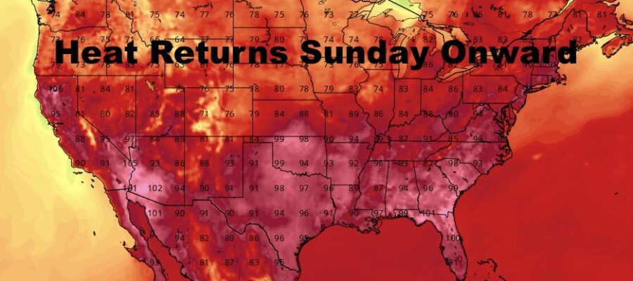
We slowly begin to warm up on Saturday with low to mid 80’s and the slight chance of a storm; then full sunshine returns and we easily pop back into the upper 80’s to near 90 on Sunday.
LOCAL RADAR NEW YORK CITY

To start your week, near 90 or possibly 90+ temps may pay a visit Monday and Tuesday, then we’ll be closely monitoring for the chance we go for low to mid 90’s Wednesday through next Friday.
LOCAL RADAR PHILADELPHIA


MANY THANKS TO TROPICAL TIDBITS FOR THE USE OF MAPS
Please note that with regards to any tropical storms or hurricanes, should a storm be threatening, please consult your local National Weather Service office or your local government officials about what action you should be taking to protect life and property.