DOWNLOAD MY NEW FREE JOESTRADAMUS WEATHER APP FOR ALL DEVICES
THE APP IS ABSOLUTELY FREE TO ALL BUT CONSIDERING SUBSCRIBING TO PATREON FOR A WEATHER EXPERIENCE FREE OF ADS, EXCLUSIVE VIDEOS FOR MEMBERS ONLY AND MUCH MORE…STARTS AT $2 A MONTH..MESSAGE ME AT ANY TIME
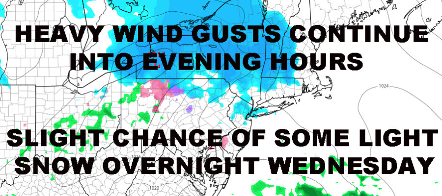
NYC HEAVY WIND GUSTS CONTINUE LIGHT SNOW POSSIBLE WED NIGHT
Good morning everyone. Low to mid 50mph gusts have been reported in the NYC area as well as areas of Long Island. Add saturated ground and vulnerable trees into the equation, the conditions are ripe for downed trees and power outages scattered throughout the region.
EASTERN SATELLITE

The sun is finally out after playing hooky yesterday afternoon, but we won’t be getting to average today temp-wise. Look for slightly below normal highs as we reach the upper the 30’s to near 40, but that windchill continues with strong, gusty winds. Winds will continue to gust in the 50-55mph range until evening, then we remain gusty and windy, but not as severe. We could also see a stray light flurry if a lake-effect snow-squall remnant can make it down here.
REGIONAL RADAR

Tomorrow, clouds increase as a weak area of energy will scoot north of the area. This was supposed to be “part” of our huge “blizzard” that never happened nor was ever going to happen. Overnight, we could see some light snow in the area, but most of the energy will be slipping to our north. We’ll keep a close eye on the radar, but most of us will be asleep as everything passes by. Highs tomorrow in the low 30’s.
As of now, I’d say we have 10-20% chance of a dusting.
LOCAL RADAR NEW YORK CITY

For Thursday, we modify slightly and back to the upper 30’s to near 40 as we watch for our next system. I continue to see a slight chance of snow overnight Thursday before changing to rain on Friday, but most of the energy hangs back until it’s warm enough for rain. I don’t see a replay of last Wednesday in terms of laying down a relatively decent amount (given our season) of snow and/or ice before things turned to rain.
The main batch of energy looks to swing in Friday evening into Saturday morning and it looks like all rain at that point.
LOCAL RADAR PHILADELPHIA


Cold air swings back in for the 2nd half of next weekend, and we start off March cold and active. However, the active part remains snow-hostile in terms of system path as of this very moment. The dance of west/north, north and south, or too far south continues.
MANY THANKS TO TROPICAL TIDBITS FOR THE USE OF MAPS
Please note that with regards to any tropical storms or hurricanes, should a storm be threatening, please consult your local National Weather Service office or your local government officials about what action you should be taking to protect life and property.