NYC LONG RANGE FEBRUARY OUTLOOK
NYC LONG RANGE FEBRUARY OUTLOOK
NYC LONG RANGE FEBRUARY OUTLOOK – Good morning everyone. We have a seasonably cold day on tap today after yesterday’s system brought a coating to an inch in parts of the NYC area, and nothing but rain and wet snowflakes for areas south and east. We have a nice weekend coming up and the long range is looking interesting for those who want a break from the first half of our bitter cold winter.
Sunny skies and a northwest breeze prevail behind yesterdays system. Look for highs in the low 30’s and wind chills a crisp 10-15 degrees at times. There will be signs of our slow warmup tonight, as clear skies and light winds yield lows only dipping into the low to mid 20’s (upper teens to low 20’s away from the city), as opposed to seeing widespread teens and single digits.
We’ll shoot for 40 tomorrow, then low 50’s and sunny skies for Saturday. With a decent west wind, it’ll feel a little cooler, but we’ll be in the 50’s nonetheless. Sunday we cool off slightly, but still above normal with upper 40’s to near 50 and sunny skies to start. Clouds will increase as the day goes on with a system approaching from the west.
On Monday, we’ll dip back into the low 40’s, with cloudy skies and the chance of some rain late. As of now, it looks as if the bulk of the rain will come in overnight Monday and into Tuesday. With a westward approach and energy going well to our north, look for 45-50 degree temps with the rain on Tuesday.
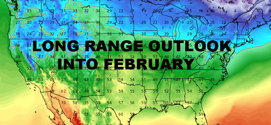
In the long range, there is no snow or arctic air in sight. The coldest of the air will be to our north and sliding to the east instead of invading deep into the Midwest and heading our way. What this means for us is any cold pockets of air that do dip down from the Great Lakes, would be short-lived.
For the rest of January and into February, look for mostly normal to above normal temps and wet conditions instead of white. This doesn’t mean we can’t get snow, but we would need something dynamic and unseen at this moment to pull it off. For example, a big system passing through with colder air behind it, then leftover energy stalled out in the south or a piece of energy coming down through the Great Lakes as our colder air moves in. Essentially, timing and circumstances will have to be perfect.
Most of our warmer spots for the next several weeks will be front-related, so don’t look for any extended periods of unseasonably warm air; but it wouldn’t surprise me to see a few spring-like days sprinkled into the mix of seasonably cool to seasonably mild days. All and all, this pattern is a breeding ground for big systems, but not a snowy one for our area.
Now we just have to keep an eye out for any surprises within the mild; the big dump of wet snow or sleet type of surprise.


NATIONAL WEATHER SERVICE SNOW FORECASTS
LATEST JOESTRADAMUS ON THE LONG RANGE
Weather App

Don’t be without Meteorologist Joe Cioffi’s weather app. It is really a meteorologist app because you get my forecasts and my analysis and not some automated computer generated forecast based on the GFS model. This is why your app forecast changes every 6 hours. It is model driven with no human input at all. It gives you an icon, a temperature and no insight whatsoever.
It is a complete weather app to suit your forecast needs. All the weather information you need is right on your phone. Android or I-phone, use it to keep track of all the latest weather information and forecasts. This weather app is also free of advertising so you don’t have to worry about security issues with your device. An accurate forecast and no worries that your device is being compromised.
Use it in conjunction with my website and my facebook and twitter and you have complete weather coverage of all the latest weather and the long range outlook. The website has been redone and upgraded. Its easy to use and everything is archived so you can see how well Joe does or doesn’t do when it comes to forecasts and outlooks.
Just click on the google play button or the apple store button on the sidebar for my app which is on My Weather Concierge. Download the app for free. Subscribe to my forecasts on an ad free environment for just 99 cents a month.
Get my forecasts in the palm of your hand for less than the cost of a cup of Joe!