NYC Long Range Outlook Shows Mostly Comfortable Conditions
Good morning everyone. We have another beautiful day today before some weather begins to move in tomorrow and sticks with us through most of Friday and parts of Saturday. Otherwise, we are fairly quiet here and don’t have much on the table aside from the high surf expected from what-will-be Hurricane Franklin late weekend into next week; as it races off into the North Atlantic safely between Bermuda and the Carolinas.
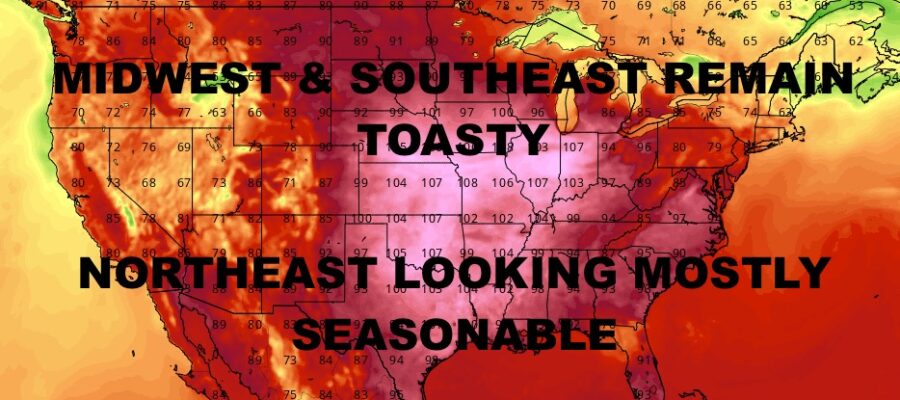
Meanwhile in the long range, a heatwave continues to ravage most of the Midwest and Southeast, with little hope for relief anytime soon. Eventually it’ll come, but all signs point to a very hot start to September and possibly into the 2nd week. For us, I don’t think we’re out of it yet in terms of some very warm to hot conditions, but we have a very big stretch of comfortable weather with very little heat to speak of aside from a front-related day here and there.
SATELLITE

For today, look for a mix of sun and clouds with highs in the upper 70’s to near 80. We’ll have another comfortable one tonight as we dip into the low 60’s, with some possible 50’s away from the City.
Clouds roll in tomorrow as energy left over from Hillary rides around the ridge to our west. This will bring the chance of on and off showers later in the day, but I believe most of the rain is off to our west. NWS is calling for the chance of storms, but I also believe the majority of that action (some of which will be severe), will also be off to our west and in central PA. Highs tomorrow in the mid 70’s.
WEATHER RADAR

On and off showers stick around for Friday, and I believe most of this round goes to our north. We’ll still see some rain though at times, but not a full washout. Expect highs in the 75-80 range depending on precip.
We’ll have a mix of sun & clouds for Saturday with the slight chance of a few scattered showers. Highs will be near 80, then we cool off for Sunday under full sunshine. Highs Sunday should be in the mid to upper 70’s with very comfortable conditions.

For the moment, it looks as if we hold onto very comfortable conditions through mid-week next week and remain dry. Highs should be in the mid to upper 70’s as well.
BE SURE TO DOWNLOAD THE FREE METEOROLOGIST JOE CIOFFI WEATHER APP &
ANGRY BEN’S FREE WEATHER APP “THE ANGRY WEATHERMAN!
MANY THANKS TO TROPICAL TIDBITS & F5 WEATHER FOR THE USE OF MAPS
Please note that with regards to any severe weather, tropical storms, or hurricanes, should a storm be threatening, please consult your local National Weather Service office or your local government officials about what action you should be taking to protect life and property.