NYC Memorial Day Weekend Shines Until Monday
05/24/24 12:12pm ET
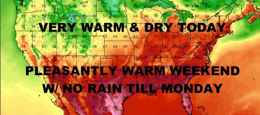
Good afternoon everyone. Much of the Northeast is basking under a really beautiful start to Memorial Day Weekend, and they’ll hold onto that great weather until Monday as the next system approaches. Very warm conditions remain behind the cold front that brought severe weather to NYC, Long Island, and even up into upper New England yesterday. Much calmer conditions prevail, even with the Monday clouds and showers that should remain light in nature.
We remain focused on the severe weather risk and we turn our eyes to Chicago with a powerful “bow echo” knocking on the door as it races through Illinois. A “bow echo” is a radar signature that resembles a bow (as in bow and arrow), bending outward which is indicative of very strong straight-line winds. Expect severe or near-severe weather conditions in the Chicago area over the course of the next hour or so; as well as areas of Wisconsin, including Milwaukee. Winds with these storms have been in excess of 60mph, with large hail and tornadoes earlier this morning.
We’re also watching late May heavy snows in areas of North Dakota as low pressure wraps up tight and draws down very cold air from the upper layers of the atmosphere. This should begin to wind down over the next few hours as low pressure finally starts to move east/northeast.
The last area of concern is parts of western Tennessee, extreme northeast Mississippi, and northern Alabama; where leftover storms from yesterday continue on and bring flooding rains and embedded severe weather. While we don’t have official severe weather watches posted, we could still see some reports of large hail, gusty winds, and of course, torrential rain.
Here is your local NYC Metro forecast –
SATELLITE

Full sunshine, very warm conditions, and low humidity rule the day for a really nice “early September” day. Highs will be a very dry mid to upper 80’s for a comfortably warm day.
WEATHER RADAR

We cool off a big tomorrow, but sunshine and low 80’s remain. Clouds begin to creep in on Sunday, but we should still see some blue patches. Highs in the upper 70’s to low 80’s.

Clouds lower and thicken on Monday, then some scattered showers as the day goes on. It’ll be much cooler as we get stuck in the upper 60’s to low 70’s.
BE SURE TO DOWNLOAD THE FREE METEOROLOGIST JOE CIOFFI WEATHER APP &
ANGRY BEN’S FREE WEATHER APP “THE ANGRY WEATHERMAN!
MANY THANKS TO TROPICAL TIDBITS & F5 WEATHER FOR THE USE OF MAPS
Please note that with regards to any severe weather, tropical storms, or hurricanes, should a storm be threatening, please consult your local National Weather Service office or your local government officials about what action you should be taking to protect life and property.