
COUPON CODE SUMMER24 GET 10% OFF
(Tempest is an affillate of Meteorologist Joe Cioffi & earns commissions on sales.)
NYC Mild Air Moves in Tomorrow
11/4/24 9:33am ET
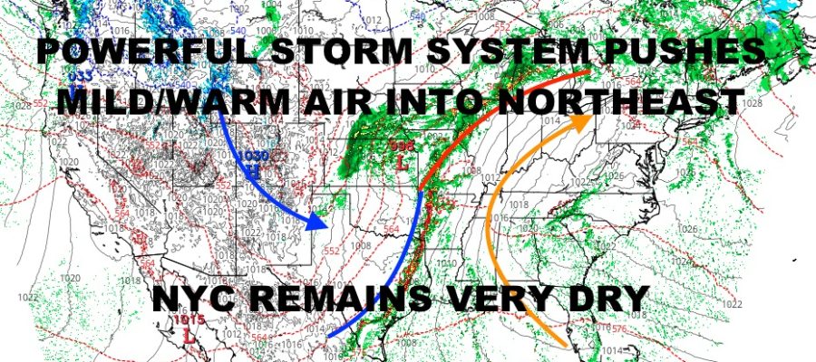
Good morning everyone. We have one more near-seasonable day in the Northeast before mild air rushes in ahead of a powerful storms system in the Midwest. 50’s and 60’s today under some clouds, will be replaced with 60’s and 70’s tomorrow. By Wednesday, some areas along the coastal plain could see some 80 degree readings before we begin to cool off a little bit.
Even with the cooldown, we’re still in the 60’s and dry. The best chance to see some rain in the Northeast will be later in the weekend as the remnants of a tropical system in the Gulf of Mexico heads into the Gulf Coast and up the Appalachians. This will prove to be a problem for areas in Tennessee and North Carolina ravaged by flooding. While we won’t see that level of rain, it will further complicate recovery and cleanup efforts.
We could see that tropical energy brush the Florida Keys and western Florida before heading ashore in a weakened state somewhere between Louisiana, Mississippi, Alabama, and the Florida Panhandle. Look for local marine hazards, gusty heavy rain, and a possible severe weather component to this typical to a landfalling tropical system.
Our main headline though remains the ongoing severe weather risk across parts of Texas, Oklahoma, Texas, Arkansas, and Kansas. While we don’t see any severe weather watches at this moment, we are still seeing locally severe weather, especially in Oklahoma. Expect our area energy to stretch out into Illinois, down into Missouri, through Louisiana, and reaches all the down into the Texas coast. As our line of severe thunderstorms stretch out, it will form into a narrow squall line with damaging winds, large hail, frequent lightning, torrential rain, and the risk of a few tornadoes.
Here is your local NYC Metro forecast –
SATELLITE

Look for a mix of sun and clouds today with near-seasonable conditions. Highs in the upper 50’s to near 60.
WEATHER RADAR

Mild air rushes in tomorrow under a mix of sun & clouds. Highs will be in the low 70’s. Southwest winds on Wednesday will help boost us into the 75-80 degree range. Best chance to see 80 degrees will be west of Manhattan in Newark, and also downtown Brooklyn/upper Queens.

Our front passes through late Wednesday night with a whimper and hardly to no rain at all. High will be in the 65-70 range Thursday under a mix of sun & clouds. Full sunshine returns on Friday with mid 60’s.
BE SURE TO DOWNLOAD THE FREE METEOROLOGIST JOE CIOFFI WEATHER APP &
ANGRY BEN’S FREE WEATHER APP “THE ANGRY WEATHERMAN!
MANY THANKS TO TROPICAL TIDBITS FOR THE USE OF MAPS
Please note that with regards to any severe weather, tropical storms, or hurricanes, should a storm be threatening, please consult your local National Weather Service office or your local government officials about what action you should be taking to protect life and property.