
Weather in 5/Joe & Joe Weather Show Latest Podcast
NYC Mild Workweek Starts Tomorrow
Good morning everyone. Our last chilly day of the workweek commences today, then we have a little taste of early spring on the way. Average highs are in the upper 40’s this time of year, so departures from average by 10-15+ degrees in some spots throughout the week will feel very mild.
SATELLITE

Regardless of what the temperatures are, the one constant through the week (till Friday) is sunshine. Look for sunshine today, light winds, and chilly highs in the low to mid 40’s.
F5 WEATHER RADARS

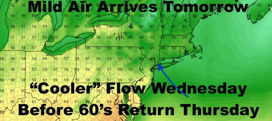
We’ll turn things around quickly tomorrow, and westerlies will help provide that sinking air we need to bust well into the 50’s and some low 60’s. Sunshine prevails, and we’ll see upper 50’s to low 60’s in most spots. We could be slightly cooler by the shore, but I don’t think the Seabreeze will be too intense tomorrow.
If you watched my video a couple of days ago, Wednesday “concerned” me as far as the wind profile and how mild do we really go? Well, it looks as if my concerns were correct, and high pressure will give us a more SSE flow. With cold ocean temps, this will knock the temps down a bit until the winds change on Thursday. It’ll still be mild as temps get into the mid to upper 50’s, but you’ll definitely feel a difference between tomorrow and Wednesday as far as a mild breeze vs. a cool breeze. It’s quite possible along the immediate south shore and Forks, that we have a hard time getting out of the upper 40’s/low 50’s.
A southwesterly flow develops on Thursday, and that’ll give us the mildest day of this stretch. We’ll keep the sunshine, and highs should be in the low to mid 60’s. Near 70 temps are possible west of the NYC area, but if the wind plays nice, we could also see some of those numbers dot downtown Brooklyn, Interior Queens, and maybe even northern Nassau County. Expect cooler conditions at the immediate shore.
Our front begins to near on Friday, bringing with it clouds and the slight chance of a shower. We’ll hold onto that mild air for 1 more day, and highs should range in the upper 50’s to low 60’s.

For our weekend, it looks as if we keep the dry stretch going, but near 50 temps Saturday will be replaced with mid 40’s Sunday as chilly air returns.
BE SURE TO DOWNLOAD THE FREE METEOROLOGIST JOE CIOFFI WEATHER APP &
ANGRY BEN’S FREE WEATHER APP “THE ANGRY WEATHERMAN!

MANY THANKS TO TROPICAL TIDBITS & F5 WEATHER FOR THE USE OF MAPS
Please note that with regards to any severe weather, tropical storms, or hurricanes, should a storm be threatening, please consult your local National Weather Service office or your local government officials about what action you should be taking to protect life and property.