
Weather in 5/Joe & Joe Weather Show Latest Podcast
NYC Milder Air Arrives Questions Remain Late Week
Good morning everyone. “Milder” air arrives today as we poke our heads above freezing and do a little melting. More melting will occur tomorrow and Thursday, but then we have some problems Friday/Friday night. I’ll get into it below.
SATELLITE

Full sunshine and mid 30’s pay a visit today, and that should start a slow melt in our area. With low 40’s tomorrow, we’ll speed it up a little bit more.
Clouds begin to increase on Thursday, and we’ll have the chance of some light rain as the day goes on. Highs in the mid 40’s will continue the melting process.
WEATHER RADAR

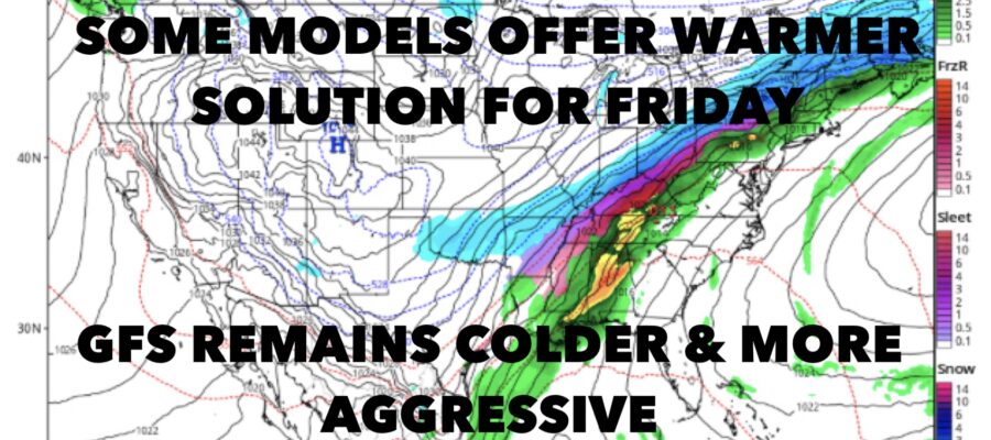
This is where the problems begin. Our elongated, slow moving cold front will meander through some time on Friday, with colder air working in and a wave of energy moving along the front at the same time. This type of setup is common in the Midwest/Lower Mid West, but it doesn’t happen very often here.
We’ve seen in the past that models, particularly the GFS, doesn’t handle these types of scenarios very well. Many times, they go very aggressive with the changeover to ice and snow. In this case, the GFS is doing just that, while the Canadian and NAM are offering a warmer solution, plus less moisture to work with once the front passes.
If I were a betting man, I’d probably lean to a warmer scenario and/or less moisture to work with behind the front. However, once in a while these scenarios do work out, which is why we need to keep the discussion going.
As I said yesterday, regardless of how this plays out, we have a major problem on our hands. With the snow we have on the ground, plus a decent amount of rain expected Friday (changeover or no changeover), a flash freeze is going to occur Friday night. With temps dropping into the teens rapidly, everything turns to ice, and our remaining snow will turn to a cement-like crusty shell.
Luckily there won’t be much commuting on Saturday, but if you do have to run out, use extreme caution.

BE SURE TO DOWNLOAD THE FREE METEOROLOGIST JOE CIOFFI WEATHER APP &
ANGRY BEN’S FREE WEATHER APP “THE ANGRY WEATHERMAN!

MANY THANKS TO TROPICAL TIDBITS & F5 WEATHER FOR THE USE OF MAPS
Please note that with regards to any severe weather, tropical storms, or hurricanes, should a storm be threatening, please consult your local National Weather Service office or your local government officials about what action you should be taking to protect life and property.