
Weather in 5/Joe & Joe Weather Show Latest Podcast
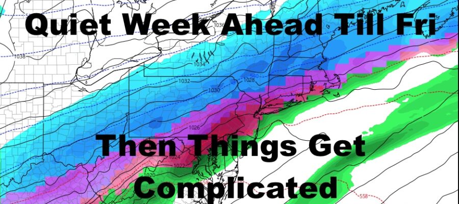
NYC Quiet Week Ahead Before Complicated Friday
Good morning everyone. We have a quiet 4 days ahead which will help with recovery and cleanup from our Blizzard. Above freezing temperatures will help a little but tomorrow through Thursday, then we have some big problems developing on Friday, snow or no snow. I’ll explain below.
SATELLITE

Sunshine fills the skies today and winds begin to settle down. Highs will remain below freezing today in the near 30 range, so don’t expect much melting today aside from areas near exposed blacktop. Lows sink back down into the 15-20 degree range tonight.
Sunshine continues tomorrow and we “warm” up a bit. Highs in the mid 30’s will help things out a bit, then low 40’s on Wednesday will get some real melting started.
WEATHER RADAR

Clouds increase Thursday in response to our next approaching system. We’ll be in the warm sector of our system for the initial start, and we should see some mid 40’s for Thursday.
The issues begin overnight Thursday into Friday, where our approaching cold front will give us some decent rain. Behind it, is another shot of some arctic air, plus a wave of energy slowly riding along that cold front. As our front passes, we have plenty of precipitation behind it. We could see a changeover of that rain to sleet, freezing rain, and snow.
How fast that changeover occurs and how much precip is left behind the front, will be key to how much we get locally here in the NYC Metro Area. As of now, I’m not touching amounts with a 10ft pole, but areas well upstate could see 4-8/6-12″ of snow out of this.
Regardless of what happens, regardless of whether we get snow or not, we have a bigger problem on our hands. With temps plummeting into the teens overnight Friday, even without snow, a flash freeze will occur between the rain we get and the melting occurring Wed-Fri morning. IF we do get snow, there will be a layer of solid ice beneath it. If we don’t, expect widespread black ice.

Things calm down again on Saturday, with slightly below average temps, then near average on Sunday. Overall, we’re entering a very active pattern and we will need to watch several features
BE SURE TO DOWNLOAD THE FREE METEOROLOGIST JOE CIOFFI WEATHER APP &
ANGRY BEN’S FREE WEATHER APP “THE ANGRY WEATHERMAN!

MANY THANKS TO TROPICAL TIDBITS & F5 WEATHER FOR THE USE OF MAPS
Please note that with regards to any severe weather, tropical storms, or hurricanes, should a storm be threatening, please consult your local National Weather Service office or your local government officials about what action you should be taking to protect life and property.