NYC Moisture Issues Impact Snow Chances Tomorrow
Good morning everyone. We’ll cut right to the chase and discuss tomorrow’s system, where some of my concerns are coming to fruition. For those who read yesterday’s forecast, I stated that my own gut feeling would be little to no accumulation, but I left the door open if several factors came together perfectly. Well, it’s not coming together perfectly and the NYC area will have a tough time getting the medium or maximum out of this system.
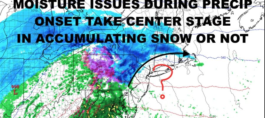
What we do have is the stubborn cold air in place and a system approaching in which overrunning precip well ahead of it should in theory give us a decent burst onset snow. What we don’t have is the moisture reaching the NYC area in a timely manner and instead, spreading over areas N&W of the City before the radar fills in here. We could still possibly see some snow, and we’ll go over it down below.
SATELLITE

For today we will enjoy a quiet, blustery, and cool one with highs in the low to mid 40’s. With that wind, bundle up because it’ll feel much colder on the skin. Clouds increase overnight with lows in the upper 20’s to near 30.
That’s cold enough to give us some onset snow, but the radar will be a big issue in the morning. Does precip arrive quick enough to give us a coating before temps climb above freezing? Does it arrive at all before it’s too warm to even snow? These are all valid questions, which is why I’m sticking to my “little to no accumulation” forecast from yesterday, but we’ll leave the door open a smidge to make room for any surprises. Either way, a “surprise” at this point for NYC and Long Island would probably equate to a coating to an inch as opposed to a 1-2/2-4″ type snowfall.
Regardless of what happens tomorrow AM, we go to rain as time goes on. With highs in the upper 30’s to low 40’s, we could see a few sleet pellets and/or wet snowflakes mixed in during the heavier precip. It’ll be all rain overnight tomorrow as temps rise into the mid to upper 40’s.
WEATHER RADAR

Thursday will see some partial clearing clearing, then maybe some late sun. It’ll be a breezy one with early highs carrying over from tomorrow night, then dropping throughout the day.
Friday is looking sunny, breezy, and cold, with highs in the mid to upper 30’s.

Your weekend remains looking quiet, with sunshine and highs in the mid 40’s. The long range is holding steady, where each system will have to be watched as colder air creeps in. So far, the first week of February remains looking fairly cold, with potentially some of the coldest temps we’ve experiencedthis season aside from that frigid blast we experienced due to that Great Lakes storm several weeks ago.
BE SURE TO DOWNLOAD THE FREE METEOROLOGIST JOE CIOFFI WEATHER APP &
ANGRY BEN’S FREE WEATHER APP “THE ANGRY WEATHERMAN!
MANY THANKS TO TROPICAL TIDBITS & F5 WEATHER FOR THE USE OF MAPS
Please note that with regards to any severe weather, tropical storms, or hurricanes, should a storm be threatening, please consult your local National Weather Service office or your local government officials about what action you should be taking to protect life and property.