NYC NEAR RECORD HIGHS PRECEDE SNOW POSSIBILITY

NYC NEAR RECORD HIGHS PRECEDE SNOW POSSIBILITY
NYC NEAR RECORD HIGHS PRECEDE SNOW POSSIBILITY – Good morning! If you’re waking up now and look outside, a gloomy morning has confronted you. Low clouds and fog will remain with us for most of the morning, then some partial clearing before the rain and thunderstorms move in. Unless we get some extra sun, record highs in NYC are doubtful, however, it’ll still be warm with highs 65-70. That being said, with the record high at 73, it won’t take much sun to edge us close.
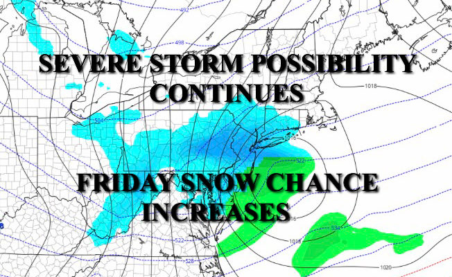
As far as rain and possible severe weather, at this point I think we get two rounds. The first one will be a broad swath of showers with embedded thunderstorms late morning to early afternoon. While things may get gusty at times and rain will also be heavy at times, I do not feel this round will contain any severe weather for the NYC area.
During late afternoon/evening, a second line of storms will move into the region. This line should be stronger but more narrow. As discussed yesterday, anything reaching here at severe limits will be a tall order, but the possibility is there, so we’ll have to keep an eye on it as things develop. It is simply impossible to predict what this line will look like right now and how it’ll look when it reaches the coast. Part of it may split up and pieces go to our north and south, so stay tuned as it unfolds.
NYC NEAR RECORD HIGHS PRECEDE SNOW POSSIBILITY – After our front passes, it’ll leave behind a sunny and windy Thursday, with highs dropping through the 40’s. At the same time, a compact, fast moving, and vigorous upper level low will head towards the area. We need to keep a close eye on it to see if it energizes a bit as it hits the coast. Because of its speed, any accumulations should be held down, but the possibility is certainly there for a very quick burst of moderate to heavy snow Friday before it departs.
After we get through today and see what this upper level disturbance looks like, I will discuss accumulation possibilities (if any), tomorrow.

A sharp cold front heads into our area, bringing with it near record highs, showers, thunderstorms, and then dropping temps and a snow possibility.

Radar is getting busy with one batch of showers and storms heading towards us for late morning. Another round is expected later and it may be stronger albeit more brief.

FiOS1 News Weather Forecast For Long Island
FiOS1 News Weather Forecast For New Jersey
FiOS1 News Weather Forecast For Hudson Valley
NATIONAL WEATHER SERVICE SNOW FORECASTS
LATEST JOESTRADAMUS ON THE LONG RANGE

Weather App

Don’t be without Meteorologist Joe Cioffi’s weather app. It is really a meteorologist app because you get my forecasts and my analysis and not some automated computer generated forecast based on the GFS model. This is why your app forecast changes every 6 hours. It is model driven with no human input at all. It gives you an icon, a temperature and no insight whatsoever.
It is a complete weather app to suit your forecast needs. All the weather information you need is right on your phone. Android or I-phone, use it to keep track of all the latest weather information and forecasts. This weather app is also free of advertising so you don’t have to worry about security issues with your device. An accurate forecast and no worries that your device is being compromised.
Use it in conjunction with my website and my facebook and twitter and you have complete weather coverage of all the latest weather and the long range outlook. The website has been redone and upgraded. Its easy to use and everything is archived so you can see how well Joe does or doesn’t do when it comes to forecasts and outlooks.
Just click on the google play button or the apple store button on the sidebar for my app which is on My Weather Concierge. Download the app for free. Subscribe to my forecasts on an ad free environment for just 99 cents a month.
Get my forecasts in the palm of your hand for less than the cost of a cup of Joe!
