
NYC NOREASTER BRINGING RAIN SNOW WIND COASTAL FLOODING
NYC NOREASTER BRINGING RAIN SNOW WIND COASTAL FLOODING
NYC NOREASTER BRINGING RAIN SNOW WIND COASTAL FLOODING – Good morning everyone. Our expected Nor’easter remains on schedule and the most important model runs this morning continue to paint a confusing picture if you’re into solely watching models.
One thing is certain at this point regardless of how the models may differ, a Nor’easter is on its way and the coast is going to get hammered as far as the usual things that Nor’easters like to do – beach erosion, coastal flooding, and minor property damage. Also, somewhere upstate between the Finger Lakes region, to Albany, and into central New England, is going to get dumped on snow-wise, but we’ll get into that in a minute.
RAINY START
Regardless of what the models say for the end of this system, the beginning will be a rainy one no matter what. This type of setup is not friendly for a NYC snowmaker, with low pressure to our WNW transferring energy close to the coast. The west approach initially keeps the atmosphere way too warm for snow, even in areas expecting to see a thumping later on, and the storm will have to work hard to change things to snow here in the NYC Metro Area. Look for rain to begin by late afternoon/evening here in NYC, then a cold rain, heavy at times tonight, with lows in the upper 30’s.
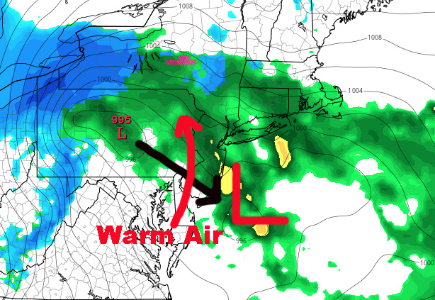
DYNAMIC AND COMPLICATED ENDING

As the low spools up, it’ll help pull down cold air from Canada, changing any rain to snow in upstate NY, northwest NJ, and northeast PA. Depending on how cold it gets and how much heavy precip is left, will dictate how much snow they eventually wind up with. Since the ground will be wet, it’ll have to come down fast to cover the ground, and/or have help with temps hovering at or just below freezing if they’re going to see some moderate to big amounts. For this reason, Winter Storm Watches and Warnings have been posted in these regions. As of now, I continue to hold onto my original gut feeling that somewhere within the Finger Lakes region and the Albany area will see the biggest accumulations.
For us down here in the NYC Metro Area, I continue to stress that the most important part of this storm for us will be the wind capable of downing trees due to the over-saturated soil, and coastal impacts. However, for those who like their snow, we could see snow mixing with rain at times, then a chance of some snow before the system departs. Overall and at BEST, I think we’d be in “cheap thrill” territory for those who enjoy the white stuff.
What will complicate the prospect of any frozen precip here, will be that warm air will continue to be pumped into eastern New England as it’s trying to pull down cold air from Canada. This typically puts us in a situation of multiple periods of rain, rain and snow, more snow than rain, then back to a plain cold rain, as the storm wobbles, precip varies in intensity, before it pulls away.
The impact of any frozen precip is looking relatively low in my book compared to the other issues we face. For those concerned about the coast, I go into full detail here on what to expect.
Stay tuned as we continue to watch how everything unfolds.


NATIONAL WEATHER SERVICE SNOW FORECASTS
LATEST JOESTRADAMUS ON THE LONG RANGE
Weather App

Don’t be without Meteorologist Joe Cioffi’s weather app. It is really a meteorologist app because you get my forecasts and my analysis and not some automated computer generated forecast based on the GFS model. This is why your app forecast changes every 6 hours. It is model driven with no human input at all. It gives you an icon, a temperature and no insight whatsoever.
It is a complete weather app to suit your forecast needs. All the weather information you need is right on your phone. Android or I-phone, use it to keep track of all the latest weather information and forecasts. This weather app is also free of advertising so you don’t have to worry about security issues with your device. An accurate forecast and no worries that your device is being compromised.
Use it in conjunction with my website and my facebook and twitter and you have complete weather coverage of all the latest weather and the long range outlook. The website has been redone and upgraded. Its easy to use and everything is archived so you can see how well Joe does or doesn’t do when it comes to forecasts and outlooks.
Just click on the google play button or the apple store button on the sidebar for my app which is on My Weather Concierge. Download the app for free. Subscribe to my forecasts on an ad free environment for just 99 cents a month.
Get my forecasts in the palm of your hand for less than the cost of a cup of Joe!