NYC Pattern Issues Through June
Good morning everyone and welcome to the long range outlook for June. Things this week look like mish-mosh of clouds and sun and lingering int he 70’s for the most part. We’ll keep that pattern going with several opportunities for some light rain and a majority Canadian/Maritime influence. We’ll explain below.
SATELLITE

For today we have clouds and sun with cool air dominating the picture. A light northerly flow will help keep things in the 60’s.
Temps modify tomorrow with clouds and sun again, highs in the mid 70’s.
WEATHER RADAR

Tuesday onward, we’ll have clouds and sun and add int he slight chance for a few showers each day. Tuesday looks like the “warmest” of the bunch with highs in the upper 70’s to near 80; then we sink back to the mid 70’s.
With this pattern, we won’t be cool and mostly cloudy all of the time, and next weekend will be a testament to that. Look for more sun than clouds on Saturday with highs near 80, then more near 80 temps Sunday with increasing clouds.

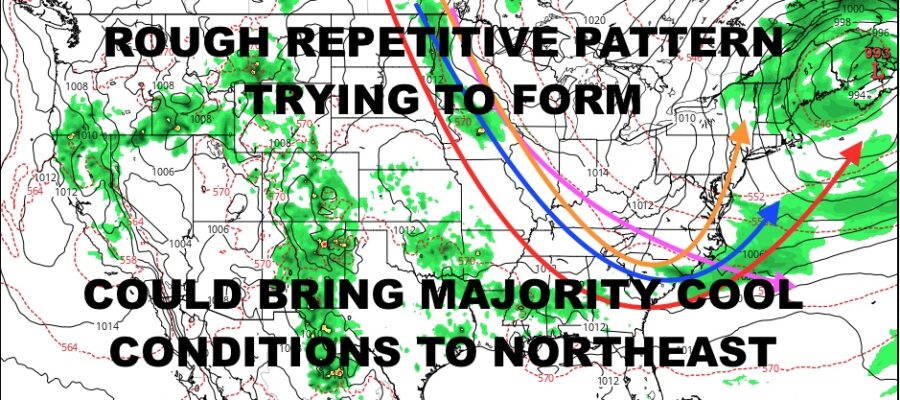
In the long range I don’t think we’re looking at multiple-washouts, but I do think this prolonged dip in the jet stream will provide extra clouds and a dominant cooler pattern. That’s not to say we can’t see a warm day here and there in between systems and transitions, but I don’t be shocked if we see a lot of low to mid 70’s for highs this month, possibly even some 60’s behind reinforcing shots of cool air or near-coastal systems.
BE SURE TO DOWNLOAD THE FREE METEOROLOGIST JOE CIOFFI WEATHER APP &
ANGRY BEN’S FREE WEATHER APP “THE ANGRY WEATHERMAN!
MANY THANKS TO TROPICAL TIDBITS & F5 WEATHER FOR THE USE OF MAPS
Please note that with regards to any severe weather, tropical storms, or hurricanes, should a storm be threatening, please consult your local National Weather Service office or your local government officials about what action you should be taking to protect life and property.