
COUPON CODE SUMMER24 GET 10% OFF
(Tempest is an affillate of Meteorologist Joe Cioffi & earns commissions on sales.)
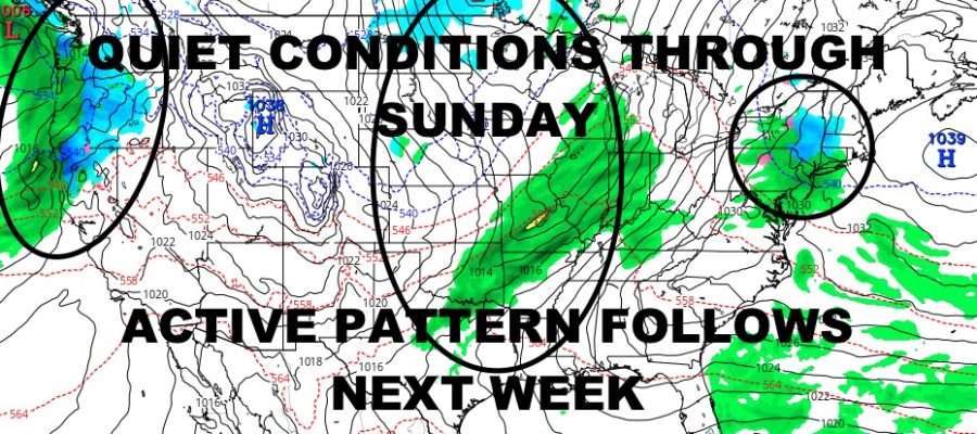
NYC Quiet Weather Ends Sunday Night
12/13/24 12:00pm EST
Good morning everyone. Although cold and still breezy in some spots, the Northeast is enjoying some very quiet weather until our next system due in late Sunday. Sunshine and 30’s prevail for the next few days, then we expect some brief onset snow, sleet, and freezing rain for interior parts of Pennsylvania, New York, and into New England.
For now, we have 2 points of focus, the Midwest and West Coast. For the Midwest, our system that’ll bring some onset frozen precipitation for parts of the Northeast, will cause some travel issues for parts of Kansas, Nebraska, Iowa, Missouri, Illinois, Minnesota, and Wisconsin as far as light snow, freezing rain, and sleet.
The main focus as far as ice and travel hazards, will be parts of central and eastern Iowa as we are expecting some heavy ice accumulations due to freezing rain. In some cases, ice accumulations could be as much as 3/10″. This may seem like a small amount, but it’s enough to make traveling downright dangerous and is typical for causing the mass accidents/pileups you’d see in the news. For this reason, the National Weather Service has issued an Ice Storm Warning for this area from midnight tonight until 3pm tomorrow.
We also have our next potent storm system coming ashore across parts of California, Oregon, and Washington. This one is expected to dump 1-3ft of snow across parts of the Sierras and Cascades as it rows inland, while heavy rain falls along the coast. We also have a wind component to this, where storm force winds are possible near the San Francisco area. Look for wind gusts in the 45-55mph range during the peak of this storm system.
Here is your local NYC Metro forecast –
SATELLITE

Sunshine rules today, but doesn’t do much as far as warming things up. Look for highs in the low 30’s at best.
WEATHER RADAR

Sunshine continues tomorrow with low to mid 30’s; then we begin to cloud up Sunday with 35-40 degree temps. Light rain and/or mix heads in late Sunday night, but any mix will turn to all rain as temps rise through the night.

We’ll have on and off rain Monday through late Tuesday morning, then partial clearing and becoming breezy. Highs will be near 50 on Monday, then upper 50’s Tuesday before dropping off.
BE SURE TO DOWNLOAD THE FREE METEOROLOGIST JOE CIOFFI WEATHER APP &
ANGRY BEN’S FREE WEATHER APP “THE ANGRY WEATHERMAN!
MANY THANKS TO TROPICAL TIDBITS FOR THE USE OF MAPS
Please note that with regards to any severe weather, tropical storms, or hurricanes, should a storm be threatening, please consult your local National Weather Service office or your local government officials about what action you should be taking to protect life and property.